I would like to create routes in Coastal Explorer (or any other suggested software) and transfer them to my MDF 12 via the SD Card. I searched and saw posts doing this with Vx2 and that the Vx2 does not accept GPX format. Does the MDF 12 support GPX import? Any pointers how to do this? Any other suggestions are welcome..
You are using an out of date browser. It may not display this or other websites correctly.
You should upgrade or use an alternative browser.
You should upgrade or use an alternative browser.
NavNet 3D and Coastal Explorer
- Thread starter s4rs
- Start date
NN3D only supports CSV file format. GPX wasn't added as an option until TZT1. I normally recommend the "SeaMarks" program from http://www.andren.com for converting files. If it is just a one time conversion, you can give a copy of the file to our support and they can convert it for you, normally. If you need to do this on a regular basis, you will want a program like SeaMarks.
Yes with NN3D, the import of points/routes/tracks is done via the SD card. If it is a MFDBB it must be a 2GB or less card used. If it is an MFD8 or MFD12 with software at or great than 2.07; it can read up to a 32GB card. You can not use anything larger.
It isn't that big but some people only have large media and get confused when it won't work.
I created a GPX route in Coastal Explorer then used GPSBabel to convert the GPX to a CSV. When I tried to import the CSV via Files I got a "No File Found" error. The SD card is recognized by the MDF12, I know the files system is good since I used the same SD card to update a map without issue. My question is does the CSV have to be in a particular format? Can I upload it so you can take a look on why it might not be recognized?
Yes CSV needs to be in a particular format. If you call or open a support case they can give you the correct format which is used. SeaMarks program uses the right CSV format when using the NN3D selection.
northcaptain
Furuno Super Fan
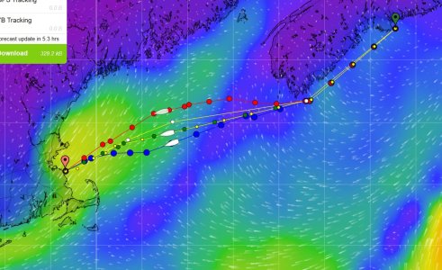
[Or someone could use TZ Navigator connected to Navnet MFD to import the GPX file and then it would be automatically translated to the Navnet world. This is what i do when tracing a weather route with PredictWind Offshore on the PC, the route is traced then exported on the PC in GPX format.
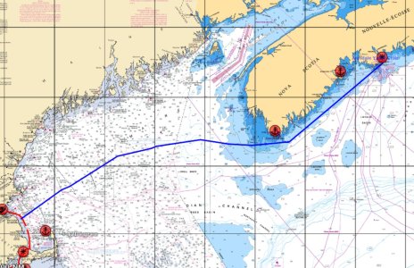
In a subsequent operation, opening TZ to import the route and it is displayed in TZ then it can be activated onto the Navnet MFD12.
Here the route in PredictWind

Here the route once imported to TZ

:sail
In a subsequent operation, opening TZ to import the route and it is displayed in TZ then it can be activated onto the Navnet MFD12.
Here the route in PredictWind

Here the route once imported to TZ

:sail
s4rs":pgp5wfc4 said:super thanks. I'll call support
Did you get this sorted out? I am having the same issue, trying to convert a gpx file to a csv and the MFD cant "find the file"
SailorBruce
New member
Johnny Electron":1jinccmc said:NN3D only supports CSV file format. GPX wasn't added as an option until TZT1. I normally recommend the "SeaMarks" program from http://www.andren.com for converting files. If it is just a one time conversion, you can give a copy of the file to our support and they can convert it for you, normally. If you need to do this on a regular basis, you will want a program like SeaMarks.
It looks like andren.com and SeaMarks has disappeared from the web. Does anyone have a copy that they archived? I need to build a way to take a GPCA file from a weather router and convert it to a CSV for the MFD12.
Obviously, I’m open to other pathways....
B
Seamarks is online and working today; at least on my PC. https://andren.com/downloads/
sailor11767
Member
I'll confirm that
- yesterday, it was broken
- today, it works.
- yesterday, it was broken
- today, it works.
Similar threads
- Replies
- 1
- Views
- 1K
R
- Replies
- 2
- Views
- 3K
R


