Radar and GPS Offsets

capdave

New member
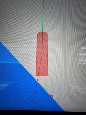
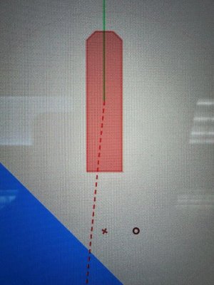
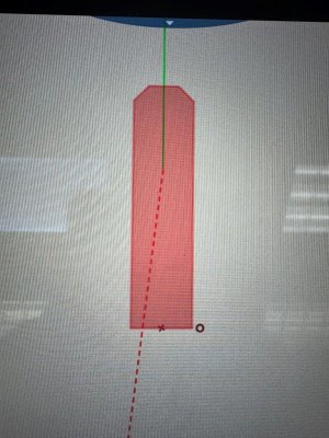
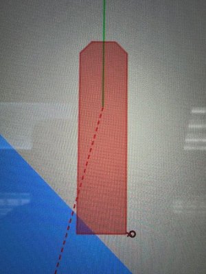
I'm trying to wrap my head around the Forward/Aft & Port/Starboard offsets for GPS sensor position and for Radar sensor position. Both sensors are located near the starboard stern of my 57' X 28' catamaran. I have entered a 53' longitudinal and 9' starboard offset for the radar sensor. When I use the 'radar only' display and zoom ALL the way in, I can see a little circle at the starboard stern of the boat cartoon, and it's clear that the radar is using this spot as the center of the display.

I have no offsets for the GPS position. If I zoom all the way in and toggle back and forth between 'radar only' and 'chart with radar overlay', it's clear that they are 53' different. And AIS targets are clearly offset from corresponding radar targets.

The chart display boat cartoon seems like it defaults to a GPS position in the middle of the cartoon, but I can't really tell. Is that true? If it is true, that means my actual bow is 53' further forward.....

The only reason all this matters is because I've started using the radar for "precision anchoring" in crowded areas. 53' actually matters when I'm trying to nail my distance off multiple surrounding boats and shore structures and reefs as I choose a spot to drop the anchor.

I guess at the least I should match the offsets on the GPS sensor and the Radar sensor? Other thoughts?
 
There are three places that need information entered for what you are looking at.
1. Home - Settings - Radar | You have entered this information already. This tells the display where your radar is located. The location is represented by a little red circle if you over zoom and the boat "cartoon" changes to a red shaded outline.
2. Home - Settings - Initial Setup - GPS Position | Enter the distance from the bow to your GPS sensor and laterally from center line to your GPS sensor. This tells the display where your GPS sensor is located. The location is represented by a little red x if you over zoom and the boat "cartoon" changes to a red shaded outline.
3. Home - Settings - Initial Setup - Boat Length | Enter the length of the vessel here. If this does not match up with the other values, the circle and x will be off the "vessel" indicator.
 

Attachments

  • IMG_8003.jpg
    IMG_8003.jpg
    192.9 KB · Views: 5
  • IMG_8004.jpg
    IMG_8004.jpg
    230.9 KB · Views: 5
  • IMG_8005.jpg
    IMG_8005.jpg
    200.1 KB · Views: 5
  • IMG_8006.jpg
    IMG_8006.jpg
    241.5 KB · Views: 5
There are three places that need information entered for what you are looking at.
1. Home - Settings - Radar | You have entered this information already. This tells the display where your radar is located. The location is represented by a little red circle if you over zoom and the boat "cartoon" changes to a red shaded outline.
2. Home - Settings - Initial Setup - GPS Position | Enter the distance from the bow to your GPS sensor and laterally from center line to your GPS sensor. This tells the display where your GPS sensor is located. The location is represented by a little red x if you over zoom and the boat "cartoon" changes to a red shaded outline.
3. Home - Settings - Initial Setup - Boat Length | Enter the length of the vessel here. If this does not match up with the other values, the circle and x will be off the "vessel" indicator.

Thanks for that. I did have boat length set at 57'. The only one missing is the GPS offset, which I just added.

So now both display modes agree, with the boat location as the starboard stern for both GPS and Radar. Overzoomed, can even see the leftover 4' sticking out aft!

So now the GPS/Radar position agree, and both indicate I've got 53' of boat sticking out forward, and 4' sticking out aft, and though it's not really shown (because there is no own ship beam, I know I've got 23' sticking out to port, and 5' sticking out to starboard.

My FA-50 AIS has its own dedicated GPS antenna, not using the same GPS as the rest of the system (which is an SC33 sat compass). I double checked that setup, and the offsets pretty much match the rest of the system now as above - there is only whole meters, nothing to the right of a decimal, still pretty close.

I guess that's good enough for now. I suppose I could manipulate the settings to either center full aft, or center full forward? Not clear how to do that, but maybe it's not important for my precision anchoring mission, where I think I care most about the transom location - just remember that 23' sticking out to port!
 
Back
Top