new 1815 causes nav data conflict

T

teffy

Guest
installed new 1815.

when the units 0183 sys is wired into the chartplotter (1871) buss it causes auto pilot and 295 nav errors. it does not allow any nav data displayed or sensed by the other units.

Is there a limit to the amount of consumers on the buss?
should i backbone the 2000 side of the 1871 to a n2k adaptor and run it to the radar?
 
It sounds like you something installed very wrong. The 1815 radar has support for NMEA 0183 and not NMEA 2000. If you have it connected to a NMEA 2000 bus without a proper converter, I recommend you disconnect it before something gets damaged. Do you have a drawing on how your units are wired?
 
let me clarify.

plan is to utilize the 2000 side of the 1871 just for the radar with appropriate converter. and wired correctly.

while i utilize the 0183 side for the other consumers. i did get complete data on the 1815 from the unit ( lat/long and wpt from my 1871, depth water temp, from my 295 etc) until i selected a waypoint on the 1871 and pressed nav on the ap35.

im still reasearching the buad rate on the ap35. currently its set at 4800. might be an issue.

ill get the wiring diagram to you. a bit under the wx with food poisoning
 
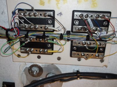
here is the drawing
 

Attachments

  • gpsbuss.pdf
    152.5 KB · Views: 58
heres a pic
 

Attachments

  • gpsbuss1 - Copy.JPG
    gpsbuss1 - Copy.JPG
    233.6 KB · Views: 897
ok did some mixing and matching. attached is the latest sketch (pardon the artwork)

finally got 1815 to work with nav function on the auto pilot (ap35).
on the 1815 i have on the stby display -speed, trip,course,wpt ttg,own ship and xte. with no issues with the autopilot on nav (so far) however i have no cursor L/L, no temp, or no depth on stand by or xmit display.

tried flip floppin the 295 gps pigtail ends but thought i would ask first.
 

Attachments

  • gpsbuss1afinal.pdf
    208.2 KB · Views: 58
I tend to use 1083 to connect one instrument to another. None of this bussbar stuff with 0183.
It is a very reliable way to connect one thing to another because it's very simple when done that way. (no potential points of failure)

If you have a whole bunch of things that want to talk to each other, and they can not be directly connected, you may need a multiplexer for 0183.

Next step up would be NMEA2000. Furuno makes a 0183-2000 converter which might work with the fcv295. You could connect some instruments directly with 0183 (like 295 to plotter) and use 2000 for everything else. Use an actisense 4-port network and it's very simple.
 
I am sorry your drawing isn't clear to me on what is being done. For the 1815 radar to have cursor Lat/Lon you must have both position and heading. This needs to be real heading not COG. I suspect your radar is not receiving heading data.
 
thanks jp498
the only thing i dont have now is temp and depth from the 295 to the 1815 and im pretty convinced its just a matter of trial and error with the 4 wire color coding.

thats what i did with the 1815 wiring. write down the wiring color coding, keep changing while documenting all steps and i finally got it. took some time. had a furuno tech at the local furuno facility also suggest the actisence multiplexor but they backed up and are 2 weeks out.

johnny i have gone over the drawing with a sharpie to enhance the look. the 1871(furuno factory cord ) to 295 ( furuno older nema 0183 4 wire black white green yellow pigtail) connections are as follows: 1871 blue to 295 black/ 1871 white to 295 white/ 1871 green to 295 green / 1871 yellow to 295 yellow

like i said its up now except for the temp depth which i could live without except i need the mark feature from the 295 to the 1871
 

Attachments

  • gpsbuss1afinal1.pdf
    284 KB · Views: 59
It isn't because the drawing is too light. It doesn't make functional sense to me because it is centered around the junctions and the units themselves are not drawn in and the input and output is not clear. Be very careful you don't take the output of two devices into one one input. This would essentially shorting out the two outputs. I agree with jp498 that you have diffrent data from diffrent units that you wish to have, a multiplexer would be best.
 
ok I have 2 gps sources 1871 and gp33
the 1871 is the primary chartplotter. i need that data to work with the 1815, 295, ap35 autopilot

secondary is the gp33. i need that data to work with the 1815, ap35, icom 504

what would a be multiplexor recommendation or suggestion ?

thanks.
 
negative

my understanding is if one system fails 1871 (nav1) the 1815 defaults to the gp33 (nav2). if this isnt the case educate me.
 
The 1815 has no such fail safe system. You should pick one source to use or establish a fail safe system externally. You don't want to send two sources of the same data to the 1815 radar.
 
ok i am getting it now.

thanks again.

im reading up on the multiplexor .
 
final resolution-

ok broke down and had a FURUNO tech come out. this is what he did

used all 3 ports from the 1815 basically splitting the info to the 1815

port 1- 1871 to 1815 provided nav data lat long to the 1815
port 2- 295 to 1815 provided temp and depth to the 1815
port 3- ap35 (nav2 output fluxgate compass) to 1815 provided heading info and cursor info

the tech had over 30 years of experience. He mentioned another situation where the cursor and heading info had to come from a heading source (not gps) like a fluxgate compass or similar to provide the info to the 1815.
 
Back
Top