Electronics for tender?

Sculler

New member
I have a tz3 on my boat
I carry a 14’ RIB tender and was looking for suggestions for a map and radio that will allow me to find my boat at anchor again as I explore but also ideally take debts soundings that I can use on my boat. Explore anchorage areas etc. I’d be open to iPad software as well.

I assume the accuracy suffers without something like the sx20 which I have on my boat.

Thoughts?
 
I don't know about having depth soundings that you can bring back to the "mothership" without spending a small pile of money. But the TZ iBoat app will allow you to navigate back to your anchorage. The GPS built into the iPad is sufficient for navigating with the RIB.
 
I wonder if a small Furuno display mounted in the tender and Wi-Fi enabled can connect with and transfer any data with the boats network upon return?

I’m overthinking this! I saw they had for mega yachts a side scan device that would do this! Lol.

I think Furuno should allow crowdmsourcing if their 3d side scan maps that users create so we can map all the little inlets.
 
If they would allow the bathymetry data to be synced to the cloud with everything else this would be possible. Though still expensive. Also keep in mind that the DFF3D doesn’t function well below 12ft of water depth.
 
gtstang462002":3qyd62dm said:
Also keep in mind that the DFF3D doesn’t function well below 12ft of water depth.
This is what's opening the door for me to be considering options from other vendors. I'd love to have better shallow water performance to let me stick with adding more Furuno gear to the tender.
 
wkearney99":3fl0am6r said:
gtstang462002":3fl0am6r said:
Also keep in mind that the DFF3D doesn’t function well below 12ft of water depth.
This is what's opening the door for me to be considering options from other vendors. I'd love to have better shallow water performance to let me stick with adding more Furuno gear to the tender.

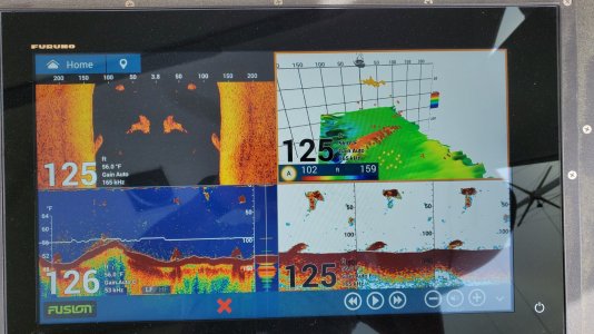
I think that Hummingbird has the market cornered with their shallow water sounders. I agree, I would love to see Furuno produce something to compete with their helix/solix lineup. I honestly don't believe that it is really in the cards given most of Furuno's Target audience in the recreation world in offshore fishing. That being said, there is a sunken submarine that is in 125' of water here in the patuxent that I can see clear as day as a small hill in on the bottom. While I can't really make it out to be a submarine if I didn't know what it was, I can make out all the fish that are holding around that structure. A local guy went over it with his Solix system, clearly identified it as a submarine but didn't show a single fish being around the structure. Personally I want to see the presence of the fish.
Resized_20210424_105141.jpeg
 
That hummingbird looks perfect. Almost want one at my boats helm as I survey anchor areas given our 14’ to deal changes.

Anyway to transfer data between them? Or mount a second one at my helm and if the tender is close transfer data between them using Wi-Fi.

I want furunos sidescan on my trawler but if it doesn’t work well at shallower depths and doesn’t go further forward in its beam it isn’t ideally suited for my need of poking into skinny water inlets and looking for rocks etc that tidal changes will reveal.
 
Hello,

it looks like the furuno ecosystem is accomplishing this with the Wassp multi beam setup.

i believe you'll need to contact furuno on the wassp/commercial side for more info., but they are doing mapping via tenders that then uploads to the charting on the large super yachts / large vessels.
 
I came to the forum to post EXACTLY the same question.

I want to use electronics on the tender to work out a route then quickly and easily (i.e. wifi or cloud, not USB key) transfer to the boat (Furuno / Nobeltec TZ Pro) to follow that same route.

I would think this is a fairly common use case yet I don't see many options. Am I missing something?

Tim
 
Slowpoke2":1i1ih2it said:
I came to the forum to post EXACTLY the same question.

I want to use electronics on the tender to work out a route then quickly and easily (i.e. wifi or cloud, not USB key) transfer to the boat (Furuno / Nobeltec TZ Pro) to follow that same route.

I would think this is a fairly common use case yet I don't see many options. Am I missing something?

I don't disagree with it being a clever idea and certainly useful. But it seems like it'd be a real stretch to call it a "common use case".

Route/track sharing among devices has long been, and continues to be, a long neglected area. Across all vendors, not just Furuno. But I'd certainly welcome smoother ways to transfer/share tracks and routes between devices.

Using bluetooth or wifi in a phone would probably be a lot more useful than on-device cloud integration. Let us 'reach into' the plotter to extract the info onto our phones and then, likewise, transfer that back out to another. Because it's one thing for our phones to have internet access, but that's nowhere near as convenient on the devices themselves, especially not on a tender. Make a hotspot on the phone, have the plotter join it, force transfers, check, repeat, etc. LOTS of steps involved. Versus the arguably simpler path of connect the phone to the plotter, see the stored tracks/routes and allow transferring them. That'd be a great option.
 
Back
Top