Connecting TZT14 to Raymarine SPX10 Autopilot

A

Anonymous

Guest
I have attached a schematic of the new Furuno setup I am installing to replace most of my Raymarine E120-era equipment. The title or my post is a bit misleading, I'll admit, because I actually have a few questions ... the first one being for the SPX10 autopilot, do I need to power the backbone cable or the drop cable (or de-power it) for the install, as diagramed? I am also adding a connection from my Yamahas command link to the same back bone, and have the same question about power for that one. I also have some questions on grounding, but let's start with these ...

Thanks, Goran
 

Attachments

  • furuno install.pdf
    84.6 KB · Views: 169
GVP55
It is great that you are planning out your install and checking it. There are too many people that "wing it" and end up in a world of hurt.

You have drawn a full backbone up at the radar scanner. It isn't needed because the bus can be terminated inside the radar scanner. You also can't have both the GP330B and the SC30 both connected to the scanner. (not enough power)

It also appears that that you have daisy chained your network cables to your main TZT14 then have it connect to your hub. That will work but not recommended because you will lose all your data to the displays if that main unit is down. It is best to take each TZT to the hub and that way not matter what each display has full access to the network items without being dependent on that one display.

When it comes to having redundant backup of GPS, your Furuno FA50 will provide basic position to the network for backup purposes so I think I would eliminate the GP330B from this install and use the SC30 and FA50.

Your lower NMEA 2000 network would need a power T to power the bus.

I haven't heard of the WS110WH RH that you are planning and need to look this SPX10 pilot. I will need to look into it and maybe provide you some suggestions. Does this pilot have it's own heading sensor or were you planning on using data from the SC30?
 
Thanks for the quick reply. Here are some more questions, in the order of your reply.

I understand your point on the radar backbone, so will terminate in radar at one end and using pin 5 at the gp330b. Also, in reading the can bus design document, it says the LEN of the sc30 is 10, and of the gp330b is 3, and I thought the radar powers ups to 20 LEN (1 amp)? So, I'd like to use a drop line for the sc30 between the two, if u think there is enough power.

I understand your point on not daisy chaining, and connecting the mFDs direct to hub

I already bought all the stuff on the diagram, and don't mind having the extra redundancy, so will keep the GP330B in, again, if u think there is enough power.

For the power to the lower can bus, should I connect power from the 18 pin cable at the back of the mFD (I assume from just one of them, and not all three), or run a separate power tee to the back bone?

The WS 110wx rh is an airmar weather unit, a lower tech version of the ws-200.
 
Thanks, Rusty, that does look very robust.

Here is the new schematic, attached.
 

Attachments

  • image.jpg
    image.jpg
    271.6 KB · Views: 2,891
I totally agree with Rusty on the backbone parts.

Although power at the scanner can support both of these, as things age and you get corrosion issues (tends to happen on boats) current will drop. It isn't so much the power but the lack of value in putting two good GPS sources on a single point of failure path. If your radar cable gets damaged or the radar scanner has an issue; you just lost both of your good sources of data. If you have one connected to the radar, then have the other on your NMEA 2000 network; it provides true redundancy in that they are two different data paths. One fails you got the other and vice versa.

My thoughts go a bit deeper about how is the best way for your heading to work with your plans. If you take the SC30 to the radar or the NMEA2000 backbone, it will be available to your 2000 network and NavNet, BUT any 0183 items can be an issue depending on how you decided to interface them. It isn't just making a physical connection. You have update rates (not baud rate) to consider, MAG/TRUE data, along with possible talker ID issues. It is best to measure several times before cutting.

I would recommend placing the WS-110 on the main NMEA 2000 bus. Since it hasn't been tested with our radar Furuno CanBus connection, it is best that it go on the main backbone. Here is an example of how your SC30 would connect to your DRS.
SC30atDRS.jpg

I haven't had the time needed to dig into this too much but I am sure other users will have suggestions also. You MUST run a regular power T for you main backbone because power thru the unit only provide limited power for 1 or 2 devices. If you did (which you wont) power thru the TZT, you would never use more than one as your power source.
 
Thanks for this info, JE. Sorry for the delay in response, I was away from a computer for a while, then got busy at work ... Anyway, with this info, I think I have it all figured out - the SPX10 is NMEA 2000, so I won't have an issue with 0183, and I've figured out all the cabling there.

I'm going to take the GP330B out of the DRS radar equation, and only do the hook-up to the SC30, exactly as you suggested. Then I'll attach the GP300B to the main CanBus backbone, and have excellent backup capabilities, as you described.

I've ordered all the connections and cabling I'll need (I think), and I hope to work on this over the long weekend with my son, hopefully being able to finish it. Will let you know how it all goes.

Attached is the final (I hope) schematic.

Thanks again, for all the help.
 

Attachments

  • funruno v2.pdf
    101.4 KB · Views: 109
Looks good.

I would ensure the shared VHF whip is rated for AIS and not just a normal VHF whip antenna. When transmitting AIS, you need to ensure it is rated for it; or you will get transmission errors.

The FLIR is a M series, correct?
 
I think I got a good VHF/AIS combo antenna, made specifically for it: http://www.milltechmarine.com/AMEC-TENT ... p_253.html
And a good splitter (I hope):
http://www.milltechmarine.com/AMEC-VHF- ... p_229.html

You have any experience with these products?

And yes, it is an M series FLIR, that I bought used (lightly). An M346 or something like that (don't have it handy).

The only thing I don't have, and I'm not sure I will get, is the weather station. There's also a Maretron weather unit (WS-001, I think) that I am thinking about.

Oh, and I have one more question that is not on the diagram. I have a Raymarine 218 VHF with DSC capability, but it is supposed to have an incoming 0183 "from a GPS", and an outgoing 0183 " to a chart plotter, to show the position of someone in distress on your screen". That second one is a nice to have, not a need to have. I assume I use something like an IF-NMEA2K2, although I'm not sure if I need one or two, or how to connect it yet.
 
The IF-NMEA2k2 can be used bi-directional with your 0183 radio to provide the unit GPS while taking DSC calling locational info to your plotter. You would need only one interface for the radio. The system you have planned is very solid and should serve you well for many years to come. Well done.
 
So I connect the radio to the 0183 connections of the IF unit, and the NMEA becomes just another drop line to the main CanBus backbone, correct?

No congrats yet - need to install it and set it up and make sure it all works first!
 
Update and 2 questions:

Things went pretty well over the weekend ... Considering. I didn't mention the boat's location, but it is Nantucket. Which got a hard, but luckily glancing, blow from hurricane Arthur on Friday. So my 3 days of work time was effectively condensed to 1.5, because I had to spend time preparing the boat (on a mooring) before, and cleaning up after. Luckily the only damage was water in the cabin, but pulling out sopping wet mattresses, as it turns out, is a huge job! Also spent some time organizing the boat's fishing gear, and cleaning, since these were the first days on the water.

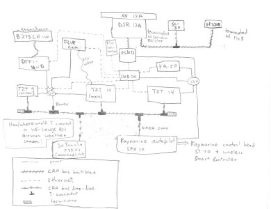
Anyway, got all the old Raymarine stuff that I won't be using out, except for the radar. And got in the two big, main MDFs. (Also installed a Garmin side scan unit / back-up chart plotter, that is totally independent from this system). Got bogged down in fabricating a panel to overlay the existing cutouts, and running some wires to the tower, so didn't do much more than that.

But the path forward is pretty clear, and there are no more difficult installs of hardware to do. Just some running of wires, which will probably be time consuming. Hopefully will be able to finish this weekend!

Anyway, for the questions: for the DRS12/SC-30 "mini-network", I need another resistor (Furuno part # 000-167-746), but can't find a place online to buy. Any ideas?

And for the FLIR unit (and potentially for my underwater camera) I was thinking of buying a video-to-IP converter so that I can see the FLIR through the ethernet (at both the upper and lower stations). Any advice of a good one to buy?
 
PM me a shipping address and I will get you a terminator (000-167-746).

If you are going to use a video to IP converter it needs to be one of the compatible Axis converters. AXIS Q7404 and AXIS 241Q are Compatible. There are software changes planned to support some of the newer Axis video servers but right now you need to stick with one of these models.
 
JE, I looked at those converters and they have 4 inputs, and are quite expensive. If I only wanted to stream the FLIR unit, and therefore only needed 1 video input, is there a cheaper version that is compatible, like the M7001, perhaps?
 
Ok, it's been a while, and it's taken some time to get things installed (running wires on my boat has been a *****), but I've got the core of the system installed. I was only able to work weekends, and some of those I fished instead. I will take some pics and send soon. Anyway, I have some questions:

The clock for the system is off, not only in hours, but in minutes. Is there some trick in setting it? I have it keying off the gps.

The spx-10 (ray marine autopilot) and the control head show up in the list of sensors, but don't seem to be sharing info

My yamahas don't show up in the list of sensors, even though I have the Yamaha interface unit connected to the can bus

I need to run a long Ethernet wire from the tower tzt9 down to the hub. Is there a 10 meter wire that has the waterproof end, or should I just connect a regular 10 meter wire with a coupler to the 3 meter waterproof that comes with it. ? And should it be a crossover coupler?
 
I have never seen a GPS off by minutes. The GPS sensor might need evaluation. Time offset should be configured in your TZtouch and then if the GPS is getting good view of the satellites, time should be correct.

If you have the TZtouch interfaced with the pilot; you must still turn on the proper PGNs needed to drive the pilot with info. (MENU - INITIAL SETUP - PGN OUTPUT)

If the Yamaha interface doesn't show up on the sensor list, then something is wrong with the interface or your NMEA 2000 backbone.

You can (now) get a longer weatherproof RJ45.
The part number for the 10 meter cable is SG3-000-000-26.

Since the ports of the Furuno (NN3D/TZT) MFDs are auto sensing, you never have to worry about straight/cross over connections.
 
Back
Top