Tzt12f - gps not accurate

tiara33bill

New member
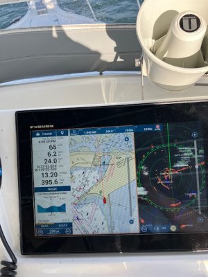
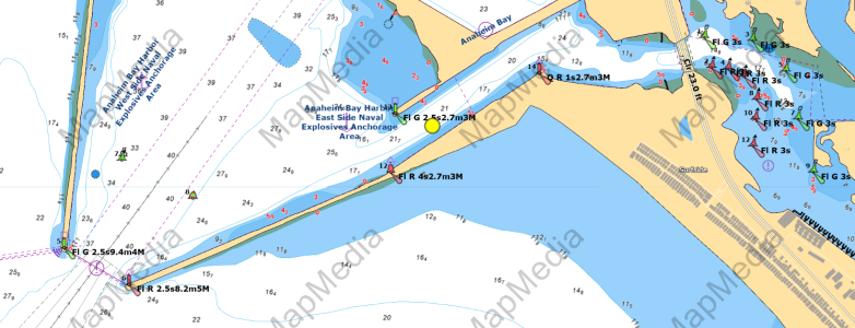
I bought a new to me boat and made the 83 mile trip from san diego to huntington harbor. While navigating in the huntington harbor, I noticed the ship's location on the chart plotter screen was really far off, looked to be several hundred yards at lest. The location indicator had the boat on shore while it's actually in the water. Radar was correct. It's been 12 years since I've owned a boat. I thought selective availability was shut off a long time ago.

I haven't had time to document how this system is put together as in which GPS antenna is used etc. I plan to do that next Tuesday depending on the weather here.

Could this be a configuration setting or a problem with them GPS antenna itself? What settings should I look for to help resolve the problem? Thanks
 

Attachments

  • IMG_0321.jpg
    IMG_0321.jpg
    112 KB · Views: 12
In settings, look at the list of sensors and preferred sources and report back what's installed and set for first choice.
 
Was there dredging in that harbor and the channel altered? Could that be out of date charts?
This is what I see when I look up that Position?
 

Attachments

  • 2-19-2024 6-27-02 PM.png
    2-19-2024 6-27-02 PM.png
    530.9 KB · Views: 9
In settings, look at the list of sensors and preferred sources and report back what's installed and set for first choice.
I hope to be able to go to the boat tomorrow and get this information. We have a lot of rain headed our way. At the very least, I'll get there on Thursday or Friday. Thanks
 
Was there dredging in that harbor and the channel altered? Could that be out of date charts?
This is what I see when I look up that Position?
yes, the navy reconfigured the harbor entrance to keep recreational boaters out of the restricted area. My understanding is they created a new narrow channel parallel to the south jetty. I was in that new channel. The furuno chartplotter showed the boat on the beach. This error would have happened prior to the reconfiguration of the harbor. This youtube video shows the changes.


thanks
 
Ok, I think I am following you, however your position looks to be correct IF at the time of your screen shot you were in fact in the channel heading at 65 degrees. What are your preferred sources? Do you have a Sat compass?

Next time you are at the boat, I would call Furuno support, they are the best support you could ever ask for.

Right now, since your heading and position look like you were in the channel the chart looks to be the issue. Please post what the fix was, would be great to learn what the issue was.
 
I think you are right. I posted this question before watching the video where he says 'don't pay attention to your chart plotter.'

The GPS is GP220B WASS Mode On
WS200 WASS On.

Looks like a false alarm. This was my first trip in the boat and first time using this device.

Thanks
 
I'd be interested to know more about the GPS antenna in use here. The TZT2s and TZT3s have a built-in GPS, but when installed in dash (as yours is in the photo), in an enclosed pilot house, or a combination of the two they don't have the strength to get a stable fix at all. An external antenna is always recommended in those applications.
 
I'd be interested to know more about the GPS antenna in use here. The TZT2s and TZT3s have a built-in GPS, but when installed in dash (as yours is in the photo), in an enclosed pilot house, or a combination of the two they don't have the strength to get a stable fix at all. An external antenna is always recommended in those applications.
I understand the problem. I have a very old Garmin GPS 76 handheld. It won't get a fix unless it has a clear view to the sky. It worked well under my soft top. The built-in GPS is second on the list so, in my installation, the external GPS antenna is the primary one. It's working just as it's supposed to.
 
Back
Top