SCX20 Reports Much Lower GNSS Altitude Than GP330B

RickVicik

Furuno Fan
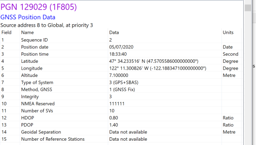
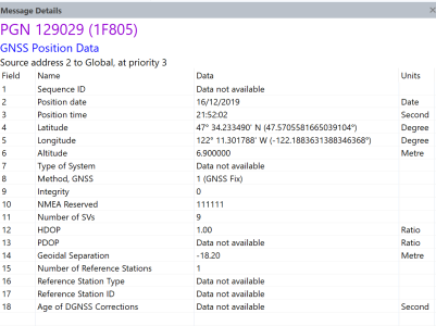
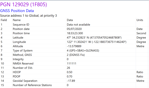
I replaced my GP330B with an SCX20. Heading and lat/long are spot-on, but while sniffing the NMEA2000 bus to resolve a different problem, I noticed the 'altitude' value in the SCX20 GNSS Position PGN (127029) was negative 14 meters. That is impossible since the boat is moored on a lake that is maintained at ~20' above MSL. The same sniffer (Actisense NGT-1) showed the GP330B and Mercruiser autopilot GPS receivers reporting positive 7 meters which is reasonable (~23' above MSL).

I am concerned that I specified something incorrectly in the setup parameters. The actual antenna height is 5.2 meters which is what I set. I tried zero and 10 meters but changing that parameter had no effect on reported altitude. Also, since the GPS receivers reporting +7 meters can't receive GLONASS, I tried disabling GLONASS in the SCX20, but the result was the same.

Any advice or information will be appreciated.

---rick
 

Attachments

  • VV7Altitude.PNG
    VV7Altitude.PNG
    52 KB · Views: 1,212
  • GP330BAltitude.PNG
    GP330BAltitude.PNG
    62.8 KB · Views: 1,212
  • SCX20Altitude.PNG
    SCX20Altitude.PNG
    50.8 KB · Views: 1,212
I verified you are correct the SCX20 has a lower offset enabled for altitude. It shouldn't change any intended function that I am aware of. Can I ask what you use Altitude for? I can let Japan know but it would be good to know how you are using it and the problem it causes by being offset.
 
Thanks for the information. I don't actually use Altitude for anything and will stop worrying that I specified something wrong in the setup parameters.

I was using the sniffer to see if I had stopped other devices on the NMEA2000 bus from sending conflicting GPS position info. That's when the negative altitude from the SCX20 caught my eye. That led me to compare the values from the different GPS receivers. Since position differed by only a few feet but altitude was off by much more, I was concerned that I specified something incorrectly in the setup parameters regarding antenna height.

---rick
 
I can confirm yours is like any new unit out of the box. I don't expect it cause any problems or be used, but I will ensure they are aware of it.
 
Okay so the engineers gave me a good lesson on this topic. It doesn't effect anything so not sure anyone cares one way or the other. They said the accuracy of altitude is not assured but for general reference the definition of "altitude" for NMEA 2000 is different than the general meaning. The general meaning of “altitude” (as well as “elevation”) is the height of an object or place above the sea, extracted from Longman for both “altitude” and “elevation”. On the other hand, “Altitude” in NMEA2000 is the altitude referenced to WGS-84 as shown in the NMEA2000 PGN standard. While the Altitude defined in NMEA2000 (altitude referenced to WGS-84) is the ellipsoidal height, altitude/elevation in “general” meaning is measured by “[ellipsoidal height (i.e. WGS-84) – [geoid height]”.
Altitude.jpg
Overall as long as it is doing what it should be doing and not causing problems; I leave the rest of that to the engineers.
 
Back
Top