Route details not using SOG

Status
Not open for further replies.

northcaptain

Furuno Super Fan
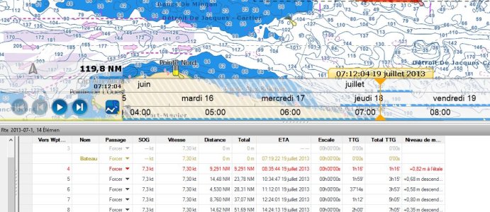
I have noticed that the route TTA and ETA are not using the SOG but rather the speed on water. This lead to a conflicting result between the Navnet3D and Maxsea. I have tried to find any options that would determine if the route TTA can use SOG but find none. Can someone shed some lights on the way it is working ?

Including a picture of my screen showing that the planned speed is in fact the speed on water.

cheers
:capt
 

Attachments

  • MaxSea SOG.JPG
    MaxSea SOG.JPG
    164.5 KB · Views: 4,758
Pending a Furuno person being on line to reply, can I ask why you think speed over water rather than SOG is being used? I too have MaxSea and run it on my laptop networked to my MFD12 & get the same screen as you show, & it has always looked to me as though planned SOG is updated with actual SOG leg by leg & divided into distance to give an updated TTG and therefore, ETA. Your screenshoot is not clear enough to read (can you attach it rather than embed it in the email?).

One discrepancy I HAVE noted between MaxSea and NN3D is that if you hover the cursor over the next waypoint on an active route, MaxSea gives you the TTG of the whole leg (even if you are 1/2-way along it) whereas NN3D gives you the actual TTG based on where you are along the leg.
 
Aquabelle thanks for the reply,

I prefer SOG because i navigate the St-Lawrence, Canada and there is always a current (sometimes 4 knots). Also there is the invariable drift when wind is blowing more than 20 knots over any mass of water. If i want to know when i'm going to arrive, better use the number that express the real progression toward the goal.

I think by clicking on the embedded file, it shows up clearly full size. Works for me.

cheers
 
northcaptain...i think you mis-understood me. I too would always use SOG...my question was WHY do you think MaxSea is using speed over water not SOG? Looks to me as though distance is being divided by SOG to give TTG?
rgds
 
I found it was using the SOW because there is a constant discrepancy between Navnet3D TTA and Maxsea TTA. When i see that i did the reverse calculation and found Maxsea was using the SOW and then tried to find if there is a parameter to control this. I have not find one...

:capt
 
I think i have found a real "bug" :) Could someone from Furuno confirm this discrepancy and if it is a feature or a bug ?

:respect
 
I don't think it is a bug. It might not be using the speed source you prefer. I have asked MaxSea to clarify what it uses for the calculation, but they haven’t answered me yet. In this case; it might be good to open a support case directly with them. http://www.maxsea.com/support
 
Hi Johnny

Thanks for the information. Indeed they claim using the SOG. They have wrote:

Note that the “Time To Go” in the route details uses the SOG (and not the VMC). This gives better “long term” information.

The TTA and ETA in the NavData are using the value from the Route Detail (the SOG that takes the current into account). This gives better “long term” information.


But this is not true. It is very easy for me to reproduce the problem that MaxSea is using the speed on water. this is why i say this is a bug.

should i open a support incident with Maxsea or do you have the setup to try it ?

Cheers
 
It would be best if you posted a support case directly with them. You have a better understanding of the issue in question. Please let us know the results.
 
A similar screenshot showing STW & SOG etc on the NavData bar would be instructive, maybe?
The route data sheet is very helpful. Thanks.
 
I had a look at this over the weekend.
It looks like SOG is calculated from STW and the currents. I have currents, and Speed and SOG are different numbers, and not the same as GPS SOG. I am happy with that. It's navigation and routing software, not a satnav.

A different problem is that FI50 cannot calibrate a DST200, so MSTZ sees uncalibrated STW on the N2K bus. Not so happy with that.

Robert
 
At least for me ist quite obvious that maxsea calculates TTA etc from Speed through water (STW) and not with Speed over ground (SOG).

From my Point of view thats the wrong way. I am sailing in high current Areas, STW? I couldnt care less, because in one direction STW is 6kts ans SOG is Zero and vice versa when I turn around......makes no sense working with stw
 
Status
Not open for further replies.
Back
Top