RDP-139 and 1700C swap

TiaraSTT

New member
Hi all,

Thanks for welcoming me to the forum. Any guidance you can provide is much appreciated. I'm a boat electronics novice and will humbly accept all feedback.

Some background: I purchased a 2003 Tiara 3100 4 months ago. I knew the RDP-139 and 1700c head units were sun-damaged because of the survey. The RDP-139 wouldn't display anything. I've had luck in the past ordering used replacement units in the past so I wasn't much worried about it.

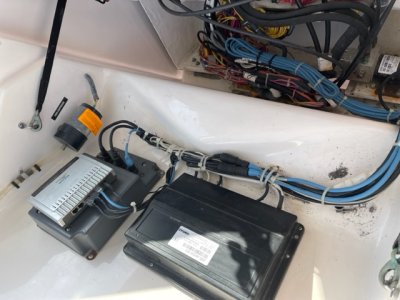
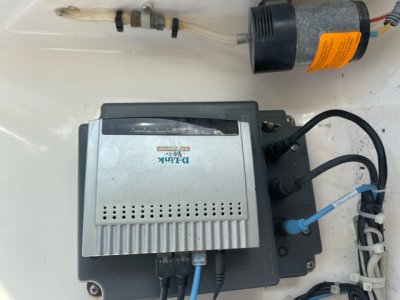
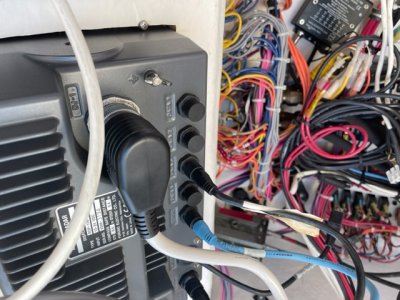
Fast forward to about 3 weeks ago. I raised this issue on my priority list and started looking for used units on EBay. I found solid looking units for each model and ordered them. When they arrived, they were exactly as advertised. I disconnected the old units and plugged in the new ones. They both powered up and looked great.

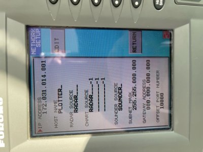
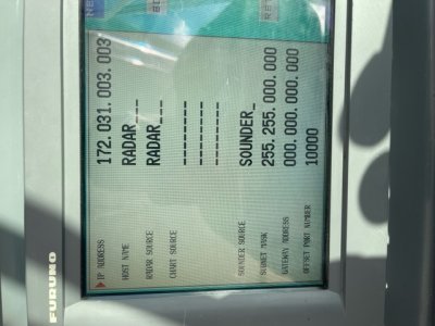
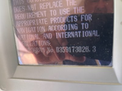
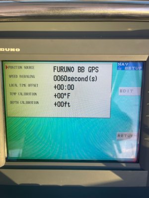
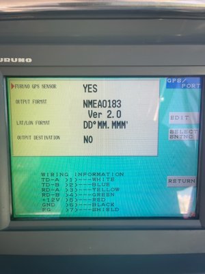
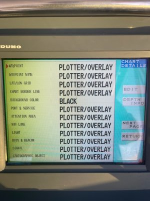
Now -- Radar information will display on both units. However, I can't get any chart information to display on either unit. I'm using a C-Maps card for the Eastern Caribbean that was in my old unit. The replacement RDP-139 I purchased says "C-Maps NT" on the front (just like the old one) so I assumed this would be a plug and play scenario. Of course, after some reading of the manual -- something I should have done before ordering the units -- i see it's more complicated than that. I'm learning the two units share data and have unique network settings. Also, the 1700C unit says "Navionics" on the chart door.

After much digging, I see both replacement units are configured with default network settings. Assuming both of the original units were the same, That should be good. Unfortunately, I can't check that.

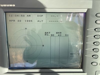
The 1700C seems to have a fix. The RDP-139 definitely does not. I left both units running overnight a couple days ago to give them plenty of time to find satellites.

I'll try to post pictures here. I can take other pics as needed. My questions are:

- Do I have a bad card? I assumed it's good since it was in the last unit.
- Am I missing a network or other setting? I think the answer is Yes.

Thanks so much for your time!
 

Attachments

  • image6.jpeg
    image6.jpeg
    114.1 KB · Views: 280
  • image5.jpeg
    image5.jpeg
    109.3 KB · Views: 280
  • image8.jpeg
    image8.jpeg
    109.7 KB · Views: 280
It is unlikely that you have a bad map card being it was just working in your last unit. It is most likely wrong or old software. Just because the door cover says C-map doesn't mean the past owner didn't load the unit with Navionics software, especially based on the smaller unit having Navionics. So the best place to start is by providing the full software number that shows up (at the bottom of the screen) on each unit as it boots.
 
Thanks so much for the response. I’ll go to the boat tomorrow and take a couple pictures of both units during boot up.

To be clear, I purchased each unit from separate sources. They weren’t purchased together. Again, probably a mistake — I went in to this project a wee bit blind. A self inflicted wound, I’m afraid.
 
Johnny ... Please see attached pictures of the bootup screen on each unit. If this isn't what you're looking for, please let me know and I'll gather more data.

Thanks again for the expert guidance. Very much appreciated.
 

Attachments

  • RDP139 bootup.jpg
    RDP139 bootup.jpg
    79.8 KB · Views: 242
  • 1700C bootup.jpg
    1700C bootup.jpg
    82.6 KB · Views: 242
The 7" NavNet one is programmed for Navionics v26. To have it run c-map charting it will need to be reprogrammed to be C-map. The 10.4" NavNet one is programmed for C-Map but the software is very old v06. The 10.4" should be updated to the newest software available. (v20) You can use this product page to get the software and instructions to upgrade your 10.4. and 7".
https://www.furunousa.com/en/support/1933C--NT

You will find what you need under the "Software" tab. You will need a PC and a basic network hub to program through. If you need advice tech support is very helpful. If you don't want to mess with it most dealers could update them or you could send them into the Furuno service center in Camas WA.

I think once updated and configured you should be fine using your old C-map NavNet one Map.
 
Thank you very much Johnny.

I don't mind the 7" unit only displaying radar, as long as doing that doesn't interfere with the overall operation. That's how I intended to use the 7" anyway. I'll focus on upgrading the 10.4" unit.

Is the old software the reason I'm not getting a Fix on the 10.4 unit?

There's a network hub that *I think* is part of the system (see attached pics). Can I connect my laptop to this hub to complete the upgrade? I briefly read through the instructions and think I can accomplish this myself. I live on St Thomas, USVI so shipping the unit for repair is a cumbersome and costly option (at best).
 

Attachments

  • Hub 2.jpg
    Hub 2.jpg
    123.1 KB · Views: 220
  • Hub 1.jpg
    Hub 1.jpg
    95.3 KB · Views: 220
  • Back of 139.jpg
    Back of 139.jpg
    159.8 KB · Views: 220
That hub looks pretty old. If you can look it up and find that it has auto sensing ports then you can use it. The issue is older networking you had to worry about cross-over cables and straight cables to ensure you would have clear communications. Newer hubs auto sense and will automatically flip the wires and make it work. You can give it a try regardless, you won't hurt anything. If your not getting position to the unit then it isn't software. You would need to look at the GPS source and data path. What GPS is connected and where is it connected?
 
Please excuse my ignorance Johnny -- how/where do I find information about my GPS source?

I can send whatever pictures and data I can. I'll go to the boat after work and look through the menus to see if I can find it.
 
I took a few pictures of the menus. I uploaded the three that seem most relevant.
 

Attachments

  • 850099B5-4B1D-4035-A7C9-55B60C3A8477.jpeg
    850099B5-4B1D-4035-A7C9-55B60C3A8477.jpeg
    87.5 KB · Views: 205
  • 489AA6E6-59C0-4E4E-A7C6-EB6A75C79C98.jpeg
    489AA6E6-59C0-4E4E-A7C6-EB6A75C79C98.jpeg
    83.3 KB · Views: 205
  • 99E2AA38-6C89-4BC6-90A8-3CBA23D920D0.jpeg
    99E2AA38-6C89-4BC6-90A8-3CBA23D920D0.jpeg
    102.6 KB · Views: 205
Also, I checked out the hub and it seems to do the auto sensing you mentioned. I’ll try the upgrade when I return from the holiday break.

I’ll be gone to the states for 7 days starting tomorrow. When I return, I’ll pickup this issue.

Thanks again for your assistance Johnny and I hope you have a great holiday season.
 

Attachments

  • 098AC1AD-0D6B-4FD8-9DBF-9810CDE8854A.jpeg
    098AC1AD-0D6B-4FD8-9DBF-9810CDE8854A.jpeg
    809.5 KB · Views: 173
Good day Johnny!

I arrived back on island late Sunday. I went to the boat yesterday with my laptop to review the diagrams and NavNet software upgrade process. I followed the cables for each input and noticed the GPS receiver was plugged into Data 1 on the small 7" unit. You mentioned the GPS could be the root cause of my issue. I switched that cable to Data 1 on the 10" unit and Voila, I had a signal and chart! I'm just fine to display radar on the small unit and chart on the larger unit.

My gut tells me to wait on the software upgrade on either unit -- unless you think there's a reason to move forward. It all seems to be working now and I hate to undo any gains I just made.

What's your opinion?
 
The GPS data can be shared between both units over the network but you must get them upgraded first and then configure properly. It sounds like you are making good progress.
 
Ok. Great to know.

What settings need to be configured for the 7" unit to share the 10" unit's GPS data? I plan to work on the upgrade this weekend and would like to close the loop on this whole thing.

Thanks again for the expert advice!
 
First you want to setup your network sources so that they will share radar and talk. Normally with NN1 the one unit the radar is directly connected to is named RADAR under the network settings. Then a second unit that is on the network would be PLOTTER. RADAR source on both units would be set to "RADAR" so they both look to the one the radar is physically connected to. Once the network is working and correct, you would look at "OUTPUT THRU NETWORK" to see what data is turned ON. From the GPS unit you would pass that data on by turning ON sentences like GGA, GLL, VTG, RMB, RMC, and ZDA. Because you don't want a data loop (bad thing) you would go to the NON-GPS unit and ensure all the sentence are turned off so it doesn't loop or regurgitate data
 
Back
Top