Hi everyone,
I'm using the 3D CUBE function in TimeZero's PBG module in an inland region of Brazil where there are no official chart maps available from the Furuno/TimeZero Store.
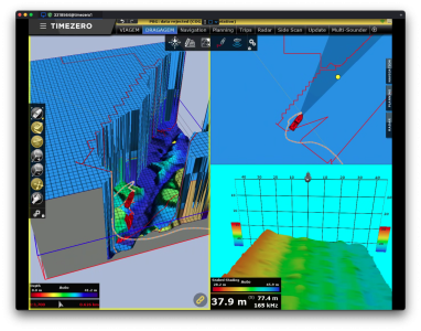
As you can see in the attached screenshot, the 3D Cube is rendering a vertical terrain column approximately 217 meters above sea level, making it look like my vessel is buried inside a massive wall. This clearly doesn’t represent the real-world bathymetry or topography of the area, and is making the visualization unusable.
My question is:
Is there any way to completely disable or ignore elevations above the water level in the 3D Cube view?
Alternatively, how can I define a maximum height or elevation cutoff so that only the underwater terrain is shown?
Any help or guidance would be appreciated. Thanks in advance!
Best regards,
Walter Andreis
I'm using the 3D CUBE function in TimeZero's PBG module in an inland region of Brazil where there are no official chart maps available from the Furuno/TimeZero Store.
As you can see in the attached screenshot, the 3D Cube is rendering a vertical terrain column approximately 217 meters above sea level, making it look like my vessel is buried inside a massive wall. This clearly doesn’t represent the real-world bathymetry or topography of the area, and is making the visualization unusable.
My question is:
Is there any way to completely disable or ignore elevations above the water level in the 3D Cube view?
Alternatively, how can I define a maximum height or elevation cutoff so that only the underwater terrain is shown?
Any help or guidance would be appreciated. Thanks in advance!
Best regards,
Walter Andreis