Furuno Charts and Navionics

Status
Not open for further replies.

Helmsman

Member
I bought two TZ3’s in November, for a build that will be completed in April due to concerns over supply chain issues. The plotters, along with a complete set of Furuno electronics is sitting in a closet awaiting the boat’s arrival.

I just found out that Navionics and Furuno have cut ties effective 3/25. My principle cruising ground is primarily the Tennessee River with seasonal trips to the Tombigbee, the Gulf Coast, and the Keys.

With the loss of Navionics, (I understand the charts that are currently on the plotter can still be unlocked and used, though not updated) what charts are available for the inland river systems?

I don’t use raster charts for several reasons. Is CMap the only other vector charts you have?

Does CMap cover the Tennessee River as well as Navionics? Are there plans to replace Navionics with vector charts? If so, when?

For the hardware, how do I ensure I get the latest updates (3/24/22) for the Navionics chart in the MapMedia library given that I won’t have the equipment installed until the end of April?

Is there any published information from Furuno with guidance on any of this. I have searched online for a couple of hours and can’t find anything.

Thanks for your help.
 
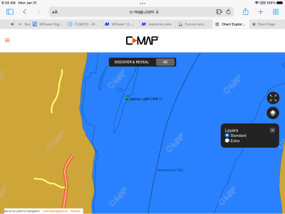
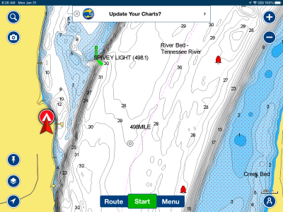
Here is a CMap file and a Navionics file to use as an example of the issue I see. The lack of detail on the CMap file is a concern. Thanks for any help you can give. The source of the Navionics is the app, which mirrors what I could get on my previous Raymarine eS127 on my previous boat. The CMap detail is is from

https://www.c-map.com/chartexplorer/

When I saved the image there were no depths available. When I looked yesterday, there were very limited depths available. I saw a marker for 5 feet and one for 15 feet in the map.


06C9C19E-55BF-43D3-A31F-6DBC0EDD2978.pngE90EF2B4-06AD-4CED-93BF-31FA00A1D802.png
 
Would you mind sharing? This is the first time I've heard of Navionics going away from Furuno, and it doesn't bode well.

Mark
 
colemj":1y0k5lac said:
Would you mind sharing? This is the first time I've heard of Navionics going away from Furuno, and it doesn't bode well.

Mark

Ok. Here is the information I received from Nobeltec Time Zero. The tech there was very helpful.

The relationship with Navionics will cease on 3/25/2022. That marks the end of a five year contract with TimeZero that was not renewed by Navionics.

If you have a Furuno chart plotter, you will be able to unlock the Navionics maps on the Furuno CP until 3/24/2022. After that, you will not be able to. If, as in my case, the MFD is uninstalled, knowing the system ID of the master chart plotter, will allow you to purchase the charts from a dealer prior to 3/24 and you will still be able to unlock when you install the CP. Time Zero will send me screen shots of selected locations from their suite of other charts to compare to other sources.

That is different from the information I received the other day from Furuno. I was told then that I would be able to unlock the Navionics after installation in April since I had purchased the Furuno equipment earlier and have received it. That is, at least the way I understood what I got from the Furuno rep. I was also urged to confirm with TimeZero. Furuno will send me screen shots of all the charts for my area of the river.

But, the most important message was that TimeZero is coming out with their own product to compete with Navionics. They expect the new charts to be out later this year. Those charts will use crowd sourcing capability so I assume that over time there will be no loss of capability. That may be particularly true with all of the fishermen out there today using Furuno equipment (who want to transmit their data back ) Again, 3/24 and 3/25 is a key date.

So, I am ok with where this stands, will use the Navionics charts in Furuno for the rivers, and switch to Furuno's new map product when it arrives and enough crowd sourced data is available to make it usable.
 
I want to say this thread isn't being ignored by the moderators. We haven't received any guidance about this from our parent company and we have requested information. I will post as soon as I get something back. I will say one really can't compare charts (even by the same chart maker) to what is available on MM3 format for Maxsea/Nobetec/NN3D/TZT/TZT2/TZT3 and iboat. Furuno USA customers can contact support with a Lat/Lon if they would like to see an example.
 
We have heard back and Furuno will be notifying dealers. Navionics will stop providing data to third party vendors which means an end to companies like MapMedia being able to provide it in the MM3 format. MapMedia will stop selling the MM3 Navionics maps options on 3/25/2022. This means if you wish to get a Navionics map in this MM3 format, it should be ordered and processed before that deadline. While there will be no further upgrades possible; it is possible to upgrade later to the equivalent C-map MM3 map for the same established upgrade price via your dealer. Those who have current license will of course continue to be able to use their purchased maps. If they need to download a copy of the map later, the links they originally received from the dealer will still be valid. Tech support can still move the license due to condemned units or joining of valid mixed systems. They can also help you find download links and unlock numbers if you lost yours. Many options for MM3 maps remain available to customers (see below) and for now anyone wishing to buy the Navionics can still place an order before the deadline.

Free Vector Charts for the USA based on Official NOAA Data
Free Raster Charts based on Official NOAA Data
Free Vector charts for the major River based on Army Corp of Engineer
For pay C-MAP Navigation data in MM3 available worldwide and Lake charts
For pay MapMedia charts and HOs charts of other countries in MM3 format.
Free and paid fishing bathy including CMOR option in MM3 Format
 
Status
Not open for further replies.
Back
Top