Hello,
Heaps of information here - thank you all! I skimmed through most of it and was hesitant to make a thread but I wanted to put together my findings, my questions/concerns, and get kind of "affirmation" that I'm on the right track. Background - 2002 Pursuit 3800 with current full furuno back from 2002, LOL. Want to go big on the install "one and done" style.
I want to go with (2) TZT16X's.
For radar, I decided to just bite the bullet and get the DRS25ANXT/4. Currently have open-array. I'm looking really to see small buoys/logs/items etc in the water more for safety - the waters here in the Santa Monica Bay don't have much to watch out for but it's more lobster buoys, random **** in the water that I want to avoid.
For autopilot - I have one Seastar BA175-7TM 13.7Cu In. I want to go with NavPilot711C with a PumpOCT16-12, is this the correct way? Asking dealer to remove the PG700 as I'll be getting the SCX20.
Two MCU006H Horizontal Remotes
Now the fun stuff:
DFF3D w/ 165T-B54
B265LH-12P
My fishing style on the west coast ranges to a multitude of different styles. Running the tuna grounds searching from 0'-200' for schools/bait/kelps. Then we could be deep dropping (max 300'-400'). Then, we could be running around kelps by the side of the island in 60-100' lower to 20' chasing white seabass/YT/bass.
Will the DFF3D utilize the 120' beam to "side-scan" in 60' of water to see in the kelps, etc? Will the B265LH interfere with the 165T-B54? I'd want to run both and at High frequency so that i can find the structure then "pinpoint" it with the B265LH with the narrow beam width.
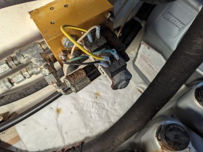
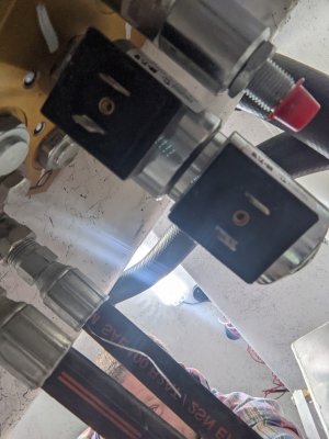
Mounting: I already have two transducers with two fairing blocks - see attached. I'm just going to put both transducers as replacing where they currently are at now, is it OK? Lastly - the B265LH has bottom discrimination, correct? Do I need the DFF1 or will the TZTXL take care of that for me?
Also - the new maps - any idea how the west coast looks like? How can I check?
Lastly - I have mechanical engines - but a company provides a J1939 data conversion and then output to NMEA2000 - if I do that can i configure it to display on the MFDs? Same with Fuel/Rudder position/etc?
Thank you in advance!


Heaps of information here - thank you all! I skimmed through most of it and was hesitant to make a thread but I wanted to put together my findings, my questions/concerns, and get kind of "affirmation" that I'm on the right track. Background - 2002 Pursuit 3800 with current full furuno back from 2002, LOL. Want to go big on the install "one and done" style.
I want to go with (2) TZT16X's.
For radar, I decided to just bite the bullet and get the DRS25ANXT/4. Currently have open-array. I'm looking really to see small buoys/logs/items etc in the water more for safety - the waters here in the Santa Monica Bay don't have much to watch out for but it's more lobster buoys, random **** in the water that I want to avoid.
For autopilot - I have one Seastar BA175-7TM 13.7Cu In. I want to go with NavPilot711C with a PumpOCT16-12, is this the correct way? Asking dealer to remove the PG700 as I'll be getting the SCX20.
Two MCU006H Horizontal Remotes
Now the fun stuff:
DFF3D w/ 165T-B54
B265LH-12P
My fishing style on the west coast ranges to a multitude of different styles. Running the tuna grounds searching from 0'-200' for schools/bait/kelps. Then we could be deep dropping (max 300'-400'). Then, we could be running around kelps by the side of the island in 60-100' lower to 20' chasing white seabass/YT/bass.
Will the DFF3D utilize the 120' beam to "side-scan" in 60' of water to see in the kelps, etc? Will the B265LH interfere with the 165T-B54? I'd want to run both and at High frequency so that i can find the structure then "pinpoint" it with the B265LH with the narrow beam width.
Mounting: I already have two transducers with two fairing blocks - see attached. I'm just going to put both transducers as replacing where they currently are at now, is it OK? Lastly - the B265LH has bottom discrimination, correct? Do I need the DFF1 or will the TZTXL take care of that for me?
Also - the new maps - any idea how the west coast looks like? How can I check?
Lastly - I have mechanical engines - but a company provides a J1939 data conversion and then output to NMEA2000 - if I do that can i configure it to display on the MFDs? Same with Fuel/Rudder position/etc?
Thank you in advance!