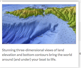
Charts, 3D bottom bathymetry

  • Thread starter Thread starter Anonymous
  • Start date Start date
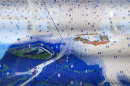
Any area outside of the USA charting, which FUSA has provided for free, would require a purchased chart. Anything included with the unit license free, outside the USA, is just a base chart and NEVER should be used for navigation. The photo you have shown indicates to me you have no purchased chart displayed. We do offer excellent charts that covers the Bahamas area for Navigation and bathy for purchase.

It could be that the chart was purchased but not properly unlocked or read from the chip.
Have you purchased any charts for this area? If so which one(s)?
 
Johnny Electron":q5btb9t9 said:
. We do offer excellent charts that covers the Bahamas area for Navigation and bathy for purchase.

Johnny,

I am aware of the charts available for purchase. I am interested to know if charts will be released in the future for the TZT2 that support the 3D bathy data that are available for the GP Models. I do not want to buy charts twice. This is what I am interested in.

http://lightmarine.c-map.com/marine-nav ... s/c-map-4d

Thanks
 
C-map bathy data is offered for several areas in the MM3 format (used by NN3D/TZT/TZT2/MaxSea/Nobletech TZ). These are bathy charts not Navigational charts. In MM3 format we have many options including C-map Navigational charts and C-map bathy data charts. For the area you are talking about in the Bahamas. You could purchase the C-map fishing bathy (MM3-FNA-022) which is fishing charts for US East Coast and the Bahamas. ($100 list)
I also recommend getting a Navigational chart if you plan to use the machine for navigation in the Bahamas. As you found out, the base chart is not designed for Navigational purposes. If you plan on going to Bermuda, then I would suggest MM3-VNA-022. (U.S. East Coast, Bahamas and Bermuda) If you don't, then I would suggest MM3-VNA-027 (Central America, Caribbean and part of Mexico) which covers the Bahamas and the Caribbean area. (Navigational maps) To get similar info as the 4D chart you are using as an example in the MM3 format, you would get both the Navigation chart ($300 list) and the bathy chart ($100 list) for the area. Just like a GP unit, you must buy a map. (unless using the free chart which are provided for the USA; in the USA waters) By the sound of it currently you have no map, hence your problem you have experienced. I hope that helps make things a bit more clear. Every system is different so it is good that you are asking the right questions.
 
Johnny,

Thank you for your willingness to help. I'm aware of the need to purchase maps for navigation and as I mentioned earlier I wasn't using my TZT2 for navigation in this case but shared my screen shot to show how far off the base maps were compared to what I have experienced in the past. I really don't want to debate that again as I'm still unable to get a clear answer to my question regarding 3D bathy data. I'm aware of what is currently available.

My question is this. Will the TZT2 support 3D bathy data that looks like this in the future?
 

Attachments

  • Screen Shot 2016-11-23 at 9.14.15 AM.png
    Screen Shot 2016-11-23 at 9.14.15 AM.png
    121.3 KB · Views: 2,899
EL39":1lrsfgjf said:
My question is this. Will the TZT2 support 3D bathy data that looks like this in the future?
No, the TZT2 does not support those 3D charts at this time. At present we do not know if 3D bathymetry is planned. We will pass along the suggestion to our parent company.
 
Melville":2s4xbule said:
EL39":2s4xbule said:
My question is this. Will the TZT2 support 3D bathy data that looks like this in the future?
No, the TZT2 does not support those 3D charts at this time. At present we do not know if 3D bathymetry is planned. We will pass along the suggestion to our parent company.

Thank you!
 
Bumping this......seems the charts are off a bit near key west as well, but not as bad as Bahamas. A friend ran aground a few years ago right where this picture was taken in Boca Grande channel between Key West and Marquesas, or thereabouts.
 
here attached....this is the fishing chart i bought. This is an island just west of key west near the marquesas.
 

Attachments

  • FullSizeRender.jpg
    FullSizeRender.jpg
    853.8 KB · Views: 2,855
cmor mapping is making some charts with underwater bathymetry for a very limited area. They are making this for simrad. Not sure why google earth just cant be converted or added to charts. The charts i purchased for my tzt2 only have narrow curved lines to show depth
changes, but zero bathymetry. Please add google earth bathymetry to our charts.

https://www.cmormapping.com/
 
Back
Top