Charts, 3D bottom bathymetry

  • Thread starter Thread starter Anonymous
  • Start date Start date
A

Anonymous

Guest
New boat new TZT215....I recreationally fish offshore and havent noticed any good 3D bottom underwater topography on my new TZT2. Recently traveled to a far off Bahamian island and bottom charts were "generic". But even in the Florida Keys the bottom is "generic" offshore unless im close in near the reefs. Admittedly im still learning the TZT2 machine so it might still be undiscovered to me. So how can i get 3D offshore topography such as in deeper than 100 feet? On google maps/earth you can see underwater topography pretty well to show potential deep water fishing spots, humps, etc. And ive been asked if TZT2 had this, because the other brands do...specifically SIMRAD.
 
Depending on when you purchased the TZT2 the Jeppesen Fishing Chart should already be in your unit. An unlock code needs to be purchased for $100 list price.

Here is a link to the chart download in case it is not there.
http://www.furunousa.com/products/produ ... ing+Charts

Once this chart is unlocked use the depth shading feature to adjust for your fishing requirements.
 
thx for quick reply.....why would my date of purchase matter? I have 2 both bought in December of last year, but one screen delaminated and the entire unit was replaced in August. The unit that was replaced is the slave....the older one is the master.
 
The reason I ask is that chart is a recent addition to our standard load.

SDNA022FISHMAP01 MM3-FNA-022 FISHING

You want to look at your chart catalog and see if the above chart is listed.
If you call our technical department on Monday they can walk you through it and advise from there.
 
I wanted to bring this back to the top and see if there any updates. I too fish the Bahamas and the charts are "lacking" at best. I've unlocked the charts for the area, used the depth shading, etc and I still find them way behind where the competition is.

Is there a timetable to have the C-Map 4D charts available for the TZT2 series anytime soon? How can they be avilabale for the GP models and not TZT2?

I spoke with the gentleman from Furuno at the Ft. Lauderdale boat show and he didn't know.

Thanks in advance.
 
Agreed the charts are completely off in western bahamas. I was there this weekend and even the depth that I was in were off by hundreds of feet in comparison to the charts, as well as the small islands and Cays, which were off by a few hundred yards. I went all the way up to the Isaac's and all the way down to Gun and Cay Sal. Only thing that seems to be right is the channel in Bimini. I took pics showing the actual depth vs supposed depth as per charts on side by side monitors.
 
Rod27-
Can you please post some pictures so we can see what you observed?
 
the picture is cut off on this thread.....if u click on it, you will see the second monitor showing depth of 1000+ feet on the sounder.

 
Rod27-
Did you happen to mark down the ships position when you took that picture? Also, what chart are you using?

This data will help as we will inform the cartography producer.
 
the picture is cut off on this thread.....if u click on it, you will see the second monitor on the right showing depth of 1000+ feet on the sounder.

I noticed this on all charts.....RASTER, VECTOR, and others on my Furuno TZT2. I noticed this discrepancy on my previous boat with NN3d years ago as well. I purchased this chart thinking it would possibly solve the problem....but it hasnt.

Mapmedia FISHINGCHARTS FISHNA022V1.1-USA East Coast and Bahamas

The location pictured is a few miles south of Bimini and Cat Cay, but north of Orange Cay.
 
The exact same charts are accurate in Key Largo and my home waters. So I don't think so. But the islands and small Cay's are also off by about the same distances. I should've taken a picture of my radar overlay over the chart which would clearly show this.
 
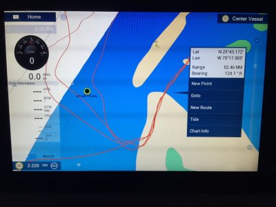
I was in Bimini over the weekend as well and here is a pic of me coming up through the channel. Obviously I didn't go over land as the chart suggests. We often arrive at night and have to rely on local knowledge as these charts are of no help.
 

Attachments

  • IMG_3395.JPG
    IMG_3395.JPG
    699.6 KB · Views: 1,728
Melville,

I'm 99% certain it's this one but I will confirm when I go back down to the boat.

MM3-USV-000
 
EL39-
That chart you list is a USA chart and not for use in the Bahamas. All USA raster and vector charts are free as the US does not charge a licensing fee.
You will need to unlock either MM3-VNA-022 which is the Jeppesen vector charts that includes the Bahamas, or MM3-R01-P00 which is the Explorer raster pack for the Bahamas.

You should not be using the free USA charts for navigation outside of the US.
 
Melville,

Yes, they are the free vector charts but I have used other free vector charts that did not have the level of error that these do.

My original intention on posting to this thread was to see if Furuno plans to make the C-Map 4d charts available for the TZT2 that are available for the GP series. I don't want to spend $300 for either of the chart packs you mentioned above as they are old technology as far as I'm concerned. I'm really interested in the 3d bathymetric data. I frequent the Bahamas regularly and being able to see the steep drops represented graphically is a huge leap forward.

I appreciate your feedback.

http://lightmarine.c-map.com/marine-nav ... s/c-map-4d
 
Plus if I did buy the Bahamas charts and they still have similar errors, why should he buy the charts? Funny the radar overlay is what brought this to light a bit more.
 
Rod-
We are dealing with 2 different issues here. First, EL39 is trying to navigate at a 2.2 mile range with a chart that is unacceptable for navigation. Using the NOAA vector or raster base in the Bahamas would be like using a restaurant place mat. It is wrong.
The other issue is you bathymetry question. If you an take a better picture, in 2d mode of your ship placement with Lat/Lon and the depth you are reading on the sounder we can get a better idea of what is going on.
Please keep in mind that the underlying data used is from approved hydrographic offices and some areas don't have current surveys. In addition this database is supplied by Jeppesen so the data on a 4D would likely be the same.
 
Melville,

I think you are having a hard time understanding the concerns and/or questions here.

I did not I say I was navigating at a 2.2 mile range on the base charts. I took a zoomed out SCREENSHOT of a trip I made over the weekend to show you how far off the base maps are. I had other means to navigate by. To Rod's point, why would I pay to unlock the Bahamas charts when he and others have reported that they are off. Base are off as well as paid. Plus I want other data besides just Vector charts which leads me to my initial reason for joining this topic and question that I have asked twice so.....for the third time.

Will FURUNO... offer some kind of 3D bathymetric charts for the TZT2...similar to what is available for the GP models via C-Map 4D? I do NOT want to pay for what is currently available if something better is coming soon.

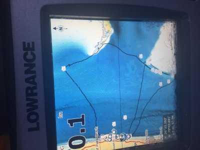
Please see the picture below, specifically the bottom right corner where you can see the long trench that runs off of South Florida. This came off of a $500 Lowrance HDS-8 with technology that is pushing 8-10 years old. This is what I and others want.

Will it be available in the near future for the TZT2????
 

Attachments

  • 3D.JPG
    3D.JPG
    704.9 KB · Views: 1,705
Back
Top