Best fishing chart for Sothern California? Not CMOR

PaDDY Killer

New member
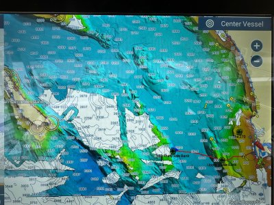
Hello, my last trip out I was with my brother fishing a spot he found the week prior at the Channel Islands here in SoCal. His app on his phone has way more detail than my C-MAP and my Navionics app I have on my tzt3 display. He was using Navionics, I will say I have not updated my maps since originally installing them.
 
I made the mistake of getting the CMOR SOCA001F for my TZT3 and they don't even have all of the southern California waters fully mapped. Plus I would have thought they would include the MPA's, but they do not. Worse yet, I got this response like waiting a year or two is alright after spending $700.

"Thanks for reaching out!

The white (NOAA Data) areas shown on the maps represent areas that have not yet been mapped.

We have big things in the works for our Southern California CMOR Chart with more coverage and updates on the way!

Our CMOR Mapping team is constantly mapping new areas and we generally like to do updates every 1 to 2 years.
 

Attachments

  • IMG_8926.jpeg
    IMG_8926.jpeg
    2.6 MB · Views: 3
Back
Top