Hey all / hi Furuno support,
hope all are well.
Bluewater cruiser here (sailing) - I guess an odd one out among many motorboaters and fishing hobbyists. Please be patient.")
So a day ago I was about to pull the trigger on replacing all my perfectly operational NavNet 3D gear with Raymarine stuff, due to the low chart detail and obvious age of the NN3D stuff.
Today I realized Furuno has released the new TZT XL line incl. 10" devices, which I can squeeze into my available space and which resolves he lacking char detail to some extent. Unfortunately, detailed information is scarce (as seems to be Furuno policy?) and as usual, the devil is in the details.
So, Furuno gets a last chance (because I love the quality and lastfulness). Please help me make an informed decision past marketing pamphlets.
Can anyone help:
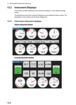
- How does the wind data display on the TZT XL / TZT10X look like? Still like its 1992? Anyone got a screenshot?
- Can the plotter show laylines on the map? Will they still look like an afterthougth (TZT3) or more professional?
- Any way to conventiently import routes from e.g. Predict Wind or still via PC only? What format?
- How does interfacing witht the TZ Nav PC software work? Via LAN only? Other connections? Still an awkward IP configuration mess like with NN3D?
- I understand the TZT XL line is still compatible with the DRS4D Radar of the NN3D family, the DFF1 Blackbox sounder and via a NMEA2000 bridge with the PG-500 fluxgate, correct? (I understand I don't get modern performance out of that).
I love my Furuno gear. Other stuff seems like toys, Furuno seems like its meaning business - I wanna give it a chance even though it seems Furuno doesnt consider sailing people their target market.
Thanks a lot!
hope all are well.
Bluewater cruiser here (sailing) - I guess an odd one out among many motorboaters and fishing hobbyists. Please be patient.
So a day ago I was about to pull the trigger on replacing all my perfectly operational NavNet 3D gear with Raymarine stuff, due to the low chart detail and obvious age of the NN3D stuff.
Today I realized Furuno has released the new TZT XL line incl. 10" devices, which I can squeeze into my available space and which resolves he lacking char detail to some extent. Unfortunately, detailed information is scarce (as seems to be Furuno policy?) and as usual, the devil is in the details.
So, Furuno gets a last chance (because I love the quality and lastfulness). Please help me make an informed decision past marketing pamphlets.
Can anyone help:
- How does the wind data display on the TZT XL / TZT10X look like? Still like its 1992? Anyone got a screenshot?
- Can the plotter show laylines on the map? Will they still look like an afterthougth (TZT3) or more professional?
- Any way to conventiently import routes from e.g. Predict Wind or still via PC only? What format?
- How does interfacing witht the TZ Nav PC software work? Via LAN only? Other connections? Still an awkward IP configuration mess like with NN3D?
- I understand the TZT XL line is still compatible with the DRS4D Radar of the NN3D family, the DFF1 Blackbox sounder and via a NMEA2000 bridge with the PG-500 fluxgate, correct? (I understand I don't get modern performance out of that).
I love my Furuno gear. Other stuff seems like toys, Furuno seems like its meaning business - I wanna give it a chance even though it seems Furuno doesnt consider sailing people their target market.
Thanks a lot!