How to create downloadable file of points for tzt12

tiara33bill

New member
The previous owner of my boat cleared all points before I bought the boat (thanks for that) so I have to recreate all points in the unit. Rather than manually entering every point, I'd like to create a file that can be downloaded (imported) to the unit so I can type on my pc instead of the display. I understand the process is some form of comma separated file. I read previous posts about using the GPX, TZD or TZX formats. I have Time Zero installed on the boat but it has no internet connection. It seems this three formats are time zero. I have 4.2 installed so it looks like I need TZX format. Is there a way to create this file without having time zero installed on my home PC?

Thanks
 
TZT3 writes and reads TZD, TZX, GPX and even CSV files.

There are many PC programs that can create, edit, and/or import/export these files. (Indeed, even a basic "notepad" can do this.)

I primarily use OpenCPN and GPS Utility (both free for PC) for my waypoint management. Because symbols/colours do not always transfer properly, I use the TZT3's decent capabily to batch change symbol/colour after transfering the waypoints. I fibd easiest to transfer using a USB stick.
thank you sailor doc
 
The previous owner of my boat cleared all points before I bought the boat (thanks for that) so I have to recreate all points in the unit. Rather than manually entering every point, I'd like to create a file that can be downloaded (imported) to the unit so I can type on my pc instead of the display. I understand the process is some form of comma separated file. I read previous posts about using the GPX, TZD or TZX formats. I have Time Zero installed on the boat but it has no internet connection. It seems this three formats are time zero. I have 4.2 installed so it looks like I need TZX format. Is there a way to create this file without having time zero installed on my home PC?

Thanks
I installed the GPS Utility software to my home pc. I changed various configuration settings so it saves points in the DMM format. I created the waypoints in a PC text document for testing purposes. I have them in a Excel CVS file too.

The software has the following fields in the database

1. record number, length 6
2. ID (name), length 17
3. Latitude/Northing, (Lat)length 12
4. Longitude/Easting, (Lon)length 12
5. Comment, (longname) length 17
6. Primary Data (Altitude), Length 8.

There are four other fields but the length is zero so I don't think they will be part of the file created for download to the unit.

Is this the correct format and order of the waypoints file on the TZT12? I can change the order of the fields in the software if necessary.

Thanks
 
I have the CSV format from NN3D that you might be able to convert into and then after in the unit you can save it as a GPX, or TZD. Programs like SeaMarks (andren.com) already have the different formats in the software to choose from. When someone needs to conduct conversions it is one of the better ones we recommend.
 

Attachments

  • Furuno CSV format.pdf
    87.4 KB · Views: 8
I have the CSV format from NN3D that you might be able to convert into and then after in the unit you can save it as a GPX, or TZD. Programs like SeaMarks (andren.com) already have the different formats in the software to choose from. When someone needs to conduct conversions it is one of the better ones we recommend.
Hi Johnny, I'll take a look at that document and try to match the GPS sofware fields to these definitions. I looked at the SeaMarks program. It looks like it might work. Thanks
 
I'm jumping on this thread with a slightly different question about waypoint transfers. Let me know if you think I should start a new thread.

I've got about 15,000 waypoints covering 500km of the Great Barrier Reef. I have had Garmin for years and with a 5000 waypoint limit I managed them by creating zones and only installing the area I intended to fish on the day. But when I upgraded to a tzt3 it can take all the waypoints and more. I have used MapSource for Garmin - its brilliant because I also have the detailed reef mapping so you can see where every points is vs the generic world map with no detail. The waypoints are also coded with symbols designating their status (house marks - fish always there, fish mark - almost always fish, picnic table - wonky holes, red dots - anchor marks, etc). But when I transferred all of the points over to the tzt3 the symbols do not get transferred. So while its great that I have all marks on the boat I have lost the symbols which is a big problem given the large area I fish and the large number of marks. My memory is not good enough to recall thousands of marks particularly when I might not fish some areas for years.

Does anyone have a solution to this?
 
15000... a LOT of wpts!

I've had problems with symbols in the past with older Furuno, and was prepared for new TZT39F. For all my waypoints, the first letter is a code for type of wpt. Happily, the TZT3 series makes it very easy to sort the waypoints (e. g., alphabetical) then I batch edit symbols to change a large group.

A problem for you if there is not some sort of code in wpt name.

You may be better off using an external program to edit wpts.
 
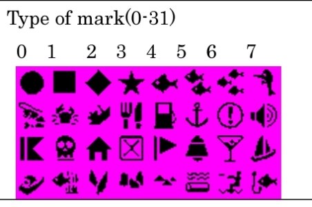
I think I might have a solution ..... I've exported the garmin data into a .csv file. I can see all the different symbols for the waypoints but I dont know the format of the Furuno data. The pdf Jonny Electron provided doesn't list out the numbering system for the waypoint symbols. So my plan is to create say 20 dummy waypoints in the furuno unit with each one having a different waypoint symbol and colour. Export that file into a .csv format so i can understand how i need to reformat the Garmin file. Once i know what new furuno symbols i want to use to replace the Garmin symbols I can use a search and replace function in excel so when i import the file it will have similar categories of waypoints. That is the theory anyway so I will see how it works in practice.
 
Back
Top