TLL capable chartplotters

Mim

New member
Hi again all. Is there a list on this site that shows what chartplotters (either Furuno or others) that have the capability of accepting TLL format waypoints? Looking through many of the posts on this forum it seems I am not the only one that wants to be able to maximise the use of the mark function on a Furuno sounder, but am getting frustrated with finding a chartplotter that accepts this format. I have seen many Furuno ones that don’t even accept it! I have seen some solutions that convert TLL to WPL which is useful for some plotters, but this just adds more costs.
 
TZT (V4.01 and above) and TZT2 (V3.01 and above) accept TLL with the use of an IF-NMEA2K2. These plotters have no NMEA0183 input.
All our products manuals will show in the specifications what data is accepted as in input or output.
 
Thanks for the reply. So if I understand this correctly...Furuno makes a very nice sounder (relatively expensive as well) that has a really useful ‘mark’ feature but to use that feature there are only limited numbers of furuno plotters that it will work on...and then you have to buy an adapter as well. :-(
Are there any plans for Furuno to update the softeware on the sounders so as to be able to choose a variety of wpt export formats...or at least a format that is more widely accepted? I imagine there would be many Furuno sounder customers that would jump for joy if this were to happen!
Again, appreciate the prompt response.
 
Unlike some of the competition, almost all Furuno sounders support TLL in some manner. What sounder unit/model exactly are you speaking of? The TZT/TZT2 are plotters, without any 0183 inputs, so the IF-NMEA2k2 converter would be used for those. If they are using a network sounder, they don't need TLL input because it is done via network. Furuno follows the NMEA standard sentencing for most standalone sounders. The TZT/TZT2 has support many points formats (input and output) like TZD, CSV, GPX. It would help to know exactly what unit you are focused on.
 
Thanks Johnny. I perhaps didnt make myself clear? I have a 588 sounder that I am very happy with. I have a Raymarine e7 that I am using as an MFD to display engine data etc but I have also managed to successfully provide GPS data to sounder via a network so that I can at least capture wpts on the 588 using the mark feature. Unfortunately I have a Navman 8120 as my primary plotter that I am very happy with but it doesn’t accept any wpt input (of any sort) so I cannot get my ‘marked’ wpts showing on my plotter. I have been investigating Furuno plotter options (of a similar size to the Navman 8120 about 10 - 12inch) to see if I could get this function to work. I had investigated a Furuno RD-149 Vx2 (see my other post) but am told this will not accept TLL wpts from an external source. I know the GP-39 does but it is not a chart plotter and is too small a screen for what I am wanting to do. So my question was what were my options to replace the Navman. I was provided with the answers above (helpful) but my comment was more about there seeming to be limited opportunities to use the mark feature on a Furuno sounder to plot captured wpts on a plotter and for the ones that can...you may also need to have an added adapter / added cost. It just seems a little weird to me.
Again, really appreciate the feedback. I guess I am expressing my frustration that I have a nice feature on my 588 that I won’t be able to make the most of unless I spend some significant dollars.
 
I had investigated a Furuno RD-149 Vx2 (see my other post) but am told this will not accept TLL wpts from an external source.
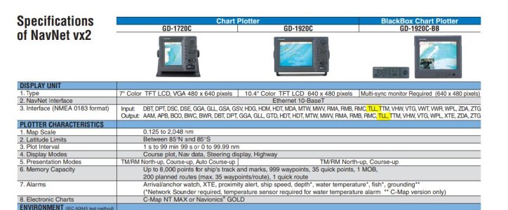
Someone told you wrong. If you have newer software the Vx2 supports both TLL In/out.
CaptureTLL.JPG

Don't confuse external waypoint (which Vx2 can also do) with TLL (Target Lat/Lon). If your goal is to have the FCV588 send over a TLL and it show up on the Vx2; there should be no problem. Of course the Vx2 is no longer sold so you will be shopping in the used market.
 
Hi there again. Just wanting to know if i can plot the TLL output from FCV588 on the MFD12 Navnet 3D GPS? The specs say no but just thought I’d check. Thanks.
 
Back
Top