RDP149 display problem

duffy

New member
I have a RDP149 networked plotter on Navnet2. It worked well until I moved the chart offset on source unit (which is the Radar and where the map card is fitted) to align with the radar image - there are significant chart/GPS errors in this area. I later removed the offset

The screen on the netwroked display now goes crazy when it is switched to plotter. It works perfectly on all other displays. I suspected a network /hub problem but switching hubs etc does not improve

The same network has a problem with AIS input to a navnet2 BB on same network. It is connected to data 2 and set for 38400 board and works well. But after a short time it tends to freeze all other data updates from other sources on other displays on the network. IS there an overload of data? The AIS is a Furuno FA150.

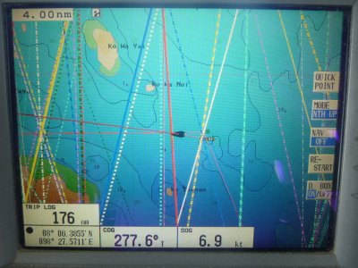
A picture of the plotter screen is attached
 

Attachments

  • RDP149 plotter screen.jpg
    RDP149 plotter screen.jpg
    268.8 KB · Views: 2,230
What is the software program numbers from the units?
It sounds like one or both unit have old software or there is a data loop of some sort going on.
 
Thanks for help
1. Radar and map source: RPU-015 = serial 4398-0187 software 1950026_0403.07. This unit also receives AD-10 data in from SC-50 on Data 3, and NMEA Navdata from same source to Data 2 at 4,800 baud.
2. Networked RDP 149 display (showing with strange lines) = serial 4323-0995 software 1950024_0403.07
3. Networked RPU-015 which receives the AIS data on port 2 at 38,400 baud and sends it out via network =
serial number 4324-1645 software 1950026_0403.07
 
software 1950026_0403.07
This is the newest C-Map 4.03 (boot loader 7) software for the NVx2 BB; no problem there.

This unit also receives AD-10 data in from SC-50 on Data 3
Good

NMEA Navdata from same source to Data 2 at 4,800 baud.
Please ensure you are NOT putting heading data from your SC50 into data 2, if you are this will cause lockups. Heading is ONLY allowed into the dedicated heading port (data 3).

Networked RDP 149 display (showing with strange lines) = serial 4323-0995 software 1950024_0403.07
The software is also the newest C-map 4.03 for a 10.4" vx2
Strange lines might be chart data related, tracking lines etc.. Suggest you try using the units without a chart card and see if the lines are there or not.

Networked RPU-015 which receives the AIS data on port 2 at 38,400 baud and sends it out via network =
serial number 4324-1645 software 1950026_0403.07
Again, good software. Don't see any issue here.

Some important things to consider when setting up your NavNet network.
NEVER turn on auto pilot NMEA sentences via Output thru Network (like APB, RMB, RMC, WPL, XTE)
NEVER turn on heading over the network because it goes over automatically with the radar data. (HDG, HDT)
NEVER allow more than one display to put out position data to the network. (GGA,GLL, VTG, ZDA)

On your normal NMEA output ports you never want to send data out (like to a RD30) and allow that said device to send that same data back to the NavNet (data loop) which can cause lockup and serious problems.

If you can't find a smoking gun.. It would be best to call our tech support while at the boat to see if we can't help you locate the problem.
 
The networked RDP-149 unit is fine for radar or sounder etc. No lines or other interference. It is only on plotter. I will try moving the SD card into that unit and running plotter from its internal map reader rather than over the network. My initia reaction was that it was a hub or network problem but other displays are OKl.

Thanks for the tip on the Navdata from SC50 - I will check the Nav Out port setup to make sure no HDG data going out on the Nav Out port : the choices are listed only as are only : GpATT, ROT, VTG,ZDA.GGA,GLL. But could it be that the AIS is also sending out position data from it own internal GPS which is causing a conflict? I am trying to get the AIS FA150 software updated so I can use the network card rather than NMEA but Furuno here seem not to have the software for this update to allow Navnet 2? Can I download it from somewhere?

Do you think it be better to put all the incoming data into the same Navnet radar unit eg GLL, VTG,ZDA Data1, AIS to Data 2 and Heading AD-10 to Data3 and leave everything else just on network? Or is this too heavy a data load?

Time to move our remaining VX2 boats to to NN3 - (next year) !

Richard
 
The photo you have reminds me a lot of lines made with the marks and lines feature. If still having issues with that display, you might try clearing your marks and lines and see if they go away.
 
Back
Top