Radar overlay won’t turn on

I was excited to get my boat back yesterday after several months away for a repower and rewire with a TZT316 and new radar system. The chart is beautiful, and the radar is impressive, but when I turn on radar overlay when in chart mode the radar will not turn on. I can run the radar in split screen mode next to the chart, but it will not overlay the chart, even when I press the Tx button.

What am I doing wrong?
Do you have a heading sensor on the network? It is necessary for radar overlay.
 
That's a great question. I'm not sure I know the answer to that. How would I know? Is there a place in the settings menu where I can find out?
 
I've just reviewed the invoice from my installer, and it appears that I did not purchase a heading sensor, so I'm guessing that the answer to my question above is no, I almost certainly do not have a heading sensor installed.

I'm somewhat confused in that my old NavnetVX2 system DID have radar overlay on the chart, but to my knowledge my old system did not have a separate heading sensor.

Where I live (on a coastal river in Savannah, Georgia), it's rare for me to actually need radar since I'm almost never out at night. But yesterday, it was foggy all day, which almost never happens here. In my hour run home from the marina, I went through some pea soup with almost zero visibility where it would have been nice to have radar overlay on the chart. I compensated by running in split screen mode with the radar next to the chart, but it would have been nice to have had the overlay.

Is there anyway I can get the radar overlay to work on the chart without purchasing a separate heading sensor? Another puzzling thing is that when I go to the "Overlay" menu on the chart, radar overlay is listed in bold as an option, whereas other alternatives that are not active are grayed out. This suggests to me that there should be a way to make it work.
 
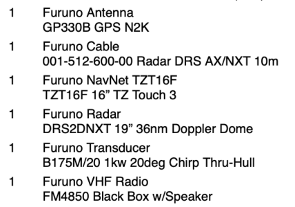
Tell us what items you have on your invoice.

If you decide to add a heading sensor, I have a BNIB PG700 I can make you a deal on.
 
I've just reviewed the invoice from my installer, and it appears that I did not purchase a heading sensor, so I'm guessing that the answer to my question above is no, I almost certainly do not have a heading sensor installed.

I'm somewhat confused in that my old NavnetVX2 system DID have radar overlay on the chart, but to my knowledge my old system did not have a separate heading sensor.

Where I live (on a coastal river in Savannah, Georgia), it's rare for me to actually need radar since I'm almost never out at night. But yesterday, it was foggy all day, which almost never happens here. In my hour run home from the marina, I went through some pea soup with almost zero visibility where it would have been nice to have radar overlay on the chart. I compensated by running in split screen mode with the radar next to the chart, but it would have been nice to have had the overlay.

Is there anyway I can get the radar overlay to work on the chart without purchasing a separate heading sensor? Another puzzling thing is that when I go to the "Overlay" menu on the chart, radar overlay is listed in bold as an option, whereas other alternatives that are not active are grayed out. This suggests to me that there should be a way to make it work.
The chart display needs the heading to align the radar overlay correctly on the chart. Do you have an autopilot? In that case you have a heading sensor. If it is networked to your TZT3, fixing the problem may be just a question of going to the initial setup menu and choosing a data source for heading.

I think there are chartplotter models from some companies that can use the course over the ground from a GPS instead of the heading from a compass for the overlay. It has been many years since I had a VX2 system. If you had an autopilot as I did, you would have had a heading sensor. I am not certain but I think the VX2 needed it for overlay also.

If you can squeeze it into your budget, the SCX-20 satellite compass is a great addition to your electronics. It will give you more accurate and stable heading data than a rate compass like the PG-700 as well as more stable GPS position, course and speed.

Looking at your equipment list, the installer did you a disservice in my opinion using a GP330B. The TZT3 internal GPS is just as good or better so you didn't need it. Better to have spent that money towards an SCX-20.
 
Thanks all for your helpful replies. No, I don’t have an autopilot. I’ll look in to the SCX-20 as well as the PG-700. Alternatively, I can just do a side by side view with the chart and the radar.
 
The radar overlay was one of the important reasons i put my magnetic PG700 as back-up and got a SCX-20.
For me the picture is way more stable with the sat compass. (The radar point forward - so to make a stable overlay on a chart the TZT need to know the heading)
So if you have deck space and budget for a SCX it may be the best for you as well.
 
So the consensus seems to be that I need either a heading sensor or a satellite compass.

Since I know only enough to be dangerous, can someone please educate me? Would it be better for me to get a heading sensor, a satellite compass, or both? If the latter, what's the difference between an SCX-20 and an SCX-21?

As background, I'm a casual, recreational boater with a 25' Whaler. I almost never go out at night, but as I discovered last weekend in pea soup fog, it would be nice for all of this stuff to work together. Having made the investment in Furuno, which as far as I can tell is top of the line in quality, I feel that I might as well go the extra mile to make this stuff functional.
 
Hi Jack.
So this is how it works.
Lets assume you normally use the sea chart North up on your display. (It is easiest to understand)
The radar is mounted pointing toward the front of your boat.
To be able to overlay the radar with sea chart you MUST supply the plotter with the heading.
The sea chart is stable on your plotter - North is always up. It does not "dance arround" or rotate.
To make a nice picture you want a radar overlay that is as stable as possible. So the heading should be as accurate as possible. If not the overlay will start to dance on the chart.

You can supply heading as:
GPS - Slow and normally not even possible since gps does not give N2k heading.
Magnetic compass - Not very stable.
Satelite compass - Fast and accurate.

I disconnected my old Magnetic PG-700 to not get any interferance but still keep as back-up.
Then I bought a new SCX.

End result for me: Much more accurate overlay..

SCX 20 ifs for N2k. 21 Is for older systems Nmea0183

Good luck
 
Thanks, Danny. This makes sense to me.

Although I will say that where I live, I tend not to use the North Up display mode because the rivers where I go are quite twisty. It's more intuitive to use "Course Up", if that makes any sense to you. If I was in a large body of water and typically cruised in a straight line over long distances, NU might make more sense.

So with the satellite compass, I assume that the overlay will still work for the "course up" display--is that correct?

Sounds like I need to get an SCX 20.....
Yes the overlay will work both North Up and Course Up.
 
Another advantage that you will pick up on your charts with a heading input is that you will be able to use heading up as an option. So if you are just drift fishing in one of those twisting rivers for example you will be able to have your charts oriented to the heading of the boat and not have to get moving to get a proper course up orientation. If you go with the SCX-20 sensor you will also pick up heaving compensation for your sounder to be able to smooth out your bottom soundings on the not so smooth days on the water.
 
So things move slowly here in Savannah, Georgia. My marine electronics guy convinced me that what I really need is a heading sensor rather than a satellite compass, saving me around a thousand bucks. So I got out on to the water for the first time this afternoon and yes, the radar overlay does indeed work, and I’m optimistic that if/when I have to navigate in inclement weather, I’ll feel safer on the water. I’m planning on using the radar overlay even on clear, sunny days so I can learn how to interpret the blips on the screen.

So here’s a question: when reading the owner’s manual for the PG-700 heading sensor, it talks about calibrating the unit for deviation, which involves pressing some buttons on the unit and driving the boat in a circle for several minutes. My heading sensor is mounted in a relatively inaccessible location in the boat.

Is there a way to calibrate the unit from the TZT3 touchscreen without having to unscrew a bunch of panels to access the unit?

Or is it even necessary to do this? As far as I can tell, I’m getting accurate data, but what do I know? As a reminder, this is on a small boat (a 25’ Whaler), and I’m rarely offshore, just using the boat for mostly inshore trips to regional islands and rivers.

As an aside, I just finished reading The Wide, Wide Sea, about Captain Cook’s last voyage to the northern Pacific Ocean in search of the Northwest Passage. He most certainly did not enjoy what we have, but I must say that I’m fascinated by the amazing technology we have at our disposal to tell us where we are. As an armchair sailor, I can highly recommend this book to anyone who wants to learn more about exploration and the collision of cultures with first contact in the age of sail.
 
I think you should take advantage of the excellent Furuno technical support and call them from your boat so they can walk you through the compass calibration procedure.

I would get a new marine electronics guy. He did not do you any favors steering you to a PG-700 versus an SCX-20. Even in a perfect installation location free of any ferrous metals that can introduce error, a PG-700 cannot equal the accuracy and performance of an SCX-20 and doesn't give you all the other benefits of better speed, course, and position data. The chart radar overlay with an SCX-20 stays perfectly aligned, which in my long experience did not happen with a rate compass like the PG700. If you add together the cost of the GP330B and PG700 he sold you, you did not really save much money either because the SCX-20 can perform the functions of both. Sorry to be a wet blanket.
 
The small incremental cost of the SCX-20 over the pg700 ($1400 versus 800) can be easily eaten up by labor dealing with troubleshooting calibration, metal parts on the boat, etc... As mentioned, you would not need the GP330b. Your dealer is stuck in the wrong decade to talk someone out of a SCX-20.
 
In fairness to the dealer, he’s mainly a Garmin guy. He wanted me to use Garmin products, I insisted on Furuno for quality issues and because that’s what I had on the boat previously. Yes, this is an annoyance, but this situation is largely a product of my ignorance and I’m just trying to learn from it and move forward. In a perfect world, I agree with you guys: the satellite compass would have been the better choice, and I still might go that route.
 
Back
Top