Data acquisition: "Current" vs. "Prefered"

Ranger

Member
Not sure what the machine is telling me. I noticed "DST200" was the "Current" data source for heading, drift, attitude, rate of turn, rudder, atmospheric pressure, air temperature, TWA/TWD/TWS, AWA/AWS... and I can't see how that makes any sense at all. The "Prefered" source for all those is "LAN" -- which makes slightly more sense.

The DST200 is actually an Airmar DST800 and had been part of the existing (at at least working) Garmin network present when we bought the boat. On the Garmin net, I changed date source to the only other offered option -- GPSMAP 7612xsv -- and that in turn changed all the "Current" values on the TZT16F network to GPSMap 7612xsv -- instead of DST200.

Still makes no sense; I'd have expected the "Current" value to match the "Prefered" value. And there isn't any value on the Garmin side of the net that I want for a source to the TZT16F.

Hesitant to try a "Reset" -- not sure what to expect...

???

-Chris
 
I have noticed that with multiple sources of the same data, the TZT 3 will sometimes choose the "wrong" source even if the "right" source is set as preferred. It may be a function of which one it sees first when the system is turned on. The fix is pretty simple -- just go back into the setting for "Data Source" and choose the correct one again. In a couple of seconds, it should shift over.

On a longer-term basis, you should probably turn off the NMEA PGN output from the Garmin 7612xsv in its settings. What do you have that supplies the wind and other data you mentioned? Do you have an SCX-20 or other compass source and an autopilot with rudder indicator on the NMEA 2000 network?
 
The fix is pretty simple -- just go back into the setting for "Data Source" and choose the correct one again. In a couple of seconds, it should shift over.

Thanks.

All of those only show a single option -- LAN -- and show the check mark, so I didn't try to re-check the check (so to speak). I think I know what you mean, and I'll try messing with that.

??


On a longer-term basis, you should probably turn off the NMEA PGN output from the Garmin 7612xsv in its settings. What do you have that supplies the wind and other data you mentioned? Do you have an SCX-20 or other compass source and an autopilot with rudder indicator on the NMEA 2000 network?

I have none of those additional instruments... and the "DST200" (DST800 depth transducer) doesn't make much sense either for those fields. Maybe that's "first one it saw" residue.

(The Garmin system is radar, simple transducer, MFD -- internal FF not supported by existing transducer -- and I don't want any Garmin info displayed on the TZT portions of the network. Useful to have Garmin depth displayed on the Garmin MFD, for redundancy, but otherwise I mentally treat the two systems as completely independent... even though the FA-70 is the one providing GPS-related info across the network.)

I noticed the data source anomalies when I began looking for what to do if I were to connect the old NMEA0183 AP to the network using an IF-NMEA2K2 "translator." I suspect I'd have to chose the fluxgate compass, somehow, as the data source for heading sentences, but since there isn't one connected now of course I'm not seeing an option to select.

While I'm on that topic... I'll mention I don't know what to expect if I were to actually connect with the interface translator. Right now, the TZT only sends NMEA0183 info to the AP via the output wires in the multi-cable. No feedback from the AP (and fluxgate compass). The Furuno/AP combo will navigate along a multi-point route well enough... although rudder changes at some waypoints can be a bit boisterous. Not sure if that'd get any better if the TZT was getting feedback from the fluxgate.

??

-Chris
 
Last edited:
A DST800 can show up as a DST200 on NMEA networks. This happens on many manufacturers and I have seen it on Garmin as well. Why it is showing up wrong I believe would be an Airmar issue.
 
Yeah, I reckoned there's some kind of naming glitch on the DST200 vs. DST800. Wasn't so concerned about that, though; willing to understand it's a triducer and leave it at that. Was more interested to know why my network thinks "Heading" can come from this kind of depth transducer.

I did maybe take one step forward and another step sideways, using suggestion from @Quitsa -- can't reset each individual values, but a full Reset did make some changes.

Before that, I made some kind of change in the Garmin MFD, so now it knows there are two separate Garmin reporters on the NMEA2000 network... one being the 7612xsv, and the other being the DST200.

Then doing that Reset on data sources in the TZT at least changed "Current" and "Prefered" so that "Heading" and all those other similar fields are now coming from the 7612xsv (versus transducer or "LAN" as before).

OTOH, I'd have thought Heading, Drift, and Rate of Turn (for example) could come from either the FA-70 or the TZT16F... and that'd certainly be my preference anyway... but neither of those is offered as a source choice for those categories.

And I don't see a way to suppress those specific PGNs -- or even the whole NMEA2000 broadcast -- from the Garmin.

-Chris
 
The preferred and current should always be the same if everything is working well. If the selected device stops putting out the PGN or it isn't heard due to "whatever", the the NavNet will start cycling the current through items trying to find the data needed from a redundant source. If it finds another good source will lock onto that "other" device and show the data in the data column. It will remain locked on to this "other" device until the primary comes back online with needed data. If the primary is heard with good PGN, it will shift over to using the primary source again. If you have something selected that the current item is cycling... it is actively looking for data because the primary is not being heard for that selected data. (sign that selected device doesn't provide that type of data or it is having a problem getting the information to the navnet.)

Yes, Airmar's DST800 units send and show up as DST200. That is normal.
 
Thanks, this is helping.

First, I wasn't so concerned about the DST200/DST800 discrepancy as I was about the DST being reported as the source for Heading, Drift, Rate of Turn, Attitude, Rudder, Atmospheric Pressure, TWA/TWD/TWS, and AWA/AWS. Whatever I did on the Garmin has caused all of those to at least now be reported as 7612xsv for both Current and Prefered. IOW, a DST is no longer being shown as bogus source for Heading and so forth. Progress.

But... now, source for all of those items is shown as 7612xsv for both Current and Prefered. While that makes slightly more sense... I'd have thought I'd be offered a chance to choose either FA-70 or TZT16F for at least Heading, Drift, Rate of Turn, and maybe Attitude? Maybe the others, too? But my only option is 7612xsv...

Also, values for all those 7612xsv fields are blank, actually, so even though the 7612xsv is shown as source, there's no info there. I'd have thought I'd be able to have Heading, Drift, Rate of Turn, and maybe Attitude from somewhere in all this, ideally the Furuno systems. Aren't those values calculated from GPS? (Or maybe there are no values because I've only checked when not underway?)

Or... if the Garmin didn't exist, from where would the TZT16F get data for those fields?

???

I think I have the FA-70 correctly set as the Garmin's GPS source, so maybe the data values the network is using might actually be OK... but still...

Finally, what brought this up was an experiment with our AP. Basically trying to discover whether connecting the AP's fluxgate compass to the network might cause any sort of improvement in navigating via AP... and if so, whether it might be enough improvement to make it worth the effort.

-Chris
 
Last edited:
Thanks, this is helping.

First, I wasn't so concerned about the DST200/DST800 discrepancy as I was about the DST being reported as the source for Heading, Drift, Rate of Turn, Attitude, Rudder, Atmospheric Pressure, TWA/TWD/TWS, and AWA/AWS. Whatever I did on the Garmin has caused all of those to at least now be reported as 7612xsv for both Current and Prefered. IOW, a DST is no longer being shown as bogus source for Heading and so forth. Progress.

But... now, source for all of those items is shown as 7612xsv for both Current and Prefered. While that makes slightly more sense... I'd have thought I'd be offered a chance to choose either FA-70 or TZT16F for at least Heading, Drift, Rate of Turn, and maybe Attitude? Maybe the others, too? But my only option is 7612xsv...

Also, values for all those 7612xsv fields are blank, actually, so even though the 7612xsv is shown as source, there's no info there. I'd have thought I'd be able to have Heading, Drift, Rate of Turn, and maybe Attitude from somewhere in all this, ideally the Furuno systems. Aren't those values calculated from GPS? (Or maybe there are no values because I've only checked when not underway?)

Or... if the Garmin didn't exist, from where would the TZT16F get data for those fields?

???

I think I have the FA-70 correctly set as the Garmin's GPS source, so maybe the data values the network is using might actually be OK... but still...

Finally, what brought this up was an experiment with our AP. Basically trying to discover whether connecting the AP's fluxgate compass to the network might cause any sort of improvement in navigating via AP... and if so, whether it might be enough improvement to make it worth the effort.

-Chris

A regular GPS unit such as the ones that are built in to the TZT 3 16 and the one in the FA-70 transponder will provide course over the ground but not heading, drift, rate of turn, or attitude. For that you would need a satellite compass like an SCX-20. The DFF-3D sounder will also supply attitude (but not heading). Your autopilot rate compass should be able to supply heading.

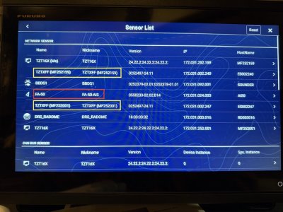
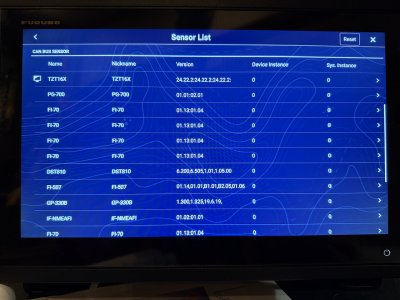
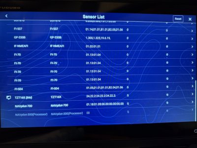
When you go into the initial settings menu and select "Sensor List", what do you see? Maybe you could call up that page and post a screen shot of it.
 
A regular GPS unit such as the ones that are built in to the TZT 3 16 and the one in the FA-70 transponder will provide course over the ground but not heading, drift, rate of turn, or attitude.

Ah! That explains much. I thought that'd be stuff that would be being calculated, while underway, from GPS info.

If I connected the AP to output NMEA0183 HDG/HDM/HDT sentences -- and if a IFNMEA2K2 translator appropriately converted all that to NMEA2000 PGN inputs -- would that maybe improve the way the system follows a route? If so, significant? Or just a tad? Or...?

The sensor list is:
Network Sensor - TZT16F (me)
Canbus Sensor - TZT16F (me), FA-70, GPSMAP 7612xsv, and DST200.

Data Sources are set to FA-70 for everything that offers that option (Posn, Mag Variation, COG, Date/Time), and set to TZT16F for everything else that offers that option (Depth, STW, SST).

All the other fields -- Heading, Attitude (Pitch/Role), Rate of Turn, Rudder, Atmospheric Pressure, Air Temperature, TWA/TWD/TWS, and AWA/AWS -- are currently at GPSMAP 7612xsv (Current) and DST200 (Prefered). Actual values for those are all blank.

Perhaps the system recognizes than none of that info could come from either the FA-70 or the TZT16F, so then it just hunts for and lands on whatever other sensor that might be on the network? Whether that sensor might be able to provide that data or not?

-Chris

Since those are the only sensors you have on the network, basically you just have three different sources of GPS position, SOG, and COG from the built-in GPS in the TZT 3, GPSMap 7612xsv, and the FA-70 and the single source of water depth and temperature and speed through the water from the DST800 (if you have the version with the paddlewheel). You could choose any one of the GPS sources. There shouldn't be much difference in performance. The FA-70 is probably the best since it has a dedicated external antenna.

If you get the heading data on the NMEA 2000 network using a converter, it might help the steering accuracy of your autopilot in following a route. You didn't say which model autopilot you have installed. What would really noticeably improve your autopilot would be a satellite compass such as the SCX-20, which has a much more precise GPS and also more accurate heading data than the autopilot's rate compass.

Do you have radar? If so, having the heading data will allow you to get radar overlay on the charts and do other positive things such as target tracking.

One thing to note is that NMEA 0183 heading output is usually done at a high baud rate. It's been many years since I had to deal with NMEA 0183 but you may need to make some adjustments to settings to make it work properly through the converter.
 
and the single source of water depth and temperature and speed through the water from the DST800 (if you have the version with the paddlewheel).

Got it, ref steering, AP compass, sat compass... thanks. There's a noticeable improvement in locations accuracy, FA-70 over the two MFDs. I think because the FA-70 GPS antenna is hardtop-mounted.

The AP is a Raymarine SmartPilot S2G, with ST8001 control head. Decent, actually... wouldn't worry much about it except it's old enough so that it will only do NMEA0183 and SeaTalk. The current TZT output -->SmartPilot input via NMEA0183 (from the multi-cable) is what's working now. Mostly 'cause it was easy, partly cause that's what I had patience to mess with at the time. Set to 38,400 Baud, I think; that was just a menu selection. Calibration is an Auto-Learn routine, without no GPS input used (seems to have worked fine). I've had AP on last boat and this for about 15 years now, but never actually tried AP navigation to points and along multi-waypoint routes before... so while I've knows the general details, I haven't known how to expect the boat to feel when acquiring a route or turning at waypoints and so forth.

Yes, have radar. Garmin thing, the real reason I've kept the Garmin MFD. Have overlays, etc. Works well enough... and saves the expense of immediate replacement.

Yes have paddlewheel on the DST800. Works, sometimes. And I also have an M525STID-MSD (Airmar B744V) transducer attached to the TZT16F... so I have DST from that, too, source reported as from the TZT16F.

While I'm at it, I'm trying to keep some data from the redundant systems obvious as to source. DST200 data on the Garmin. B744V data on the TZT. Et cetera...

-Chris
 
I believe that autopilot has a SeaTalk por.t, which is Raymarine's proprietary predecessor to NMEA 2000. There are adapter cables that would allow you to connect .it directly to the NMEA 2000 network instead of using a NMEA 0183 converter
 
I believe that autopilot has a SeaTalk por.t, which is Raymarine's proprietary predecessor to NMEA 2000. There are adapter cables that would allow you to connect .it directly to the NMEA 2000 network instead of using a NMEA 0183 converter

Yes, it has SeaTalk (SeaTalk 1) but near as I can tell, output from SeaTalk (NMEA0183 wannabee) isn't directly useable as potential input to a NMEA2000 network. Correct me, if that's wrong? And so far, I’m only aware of Furuno’s IF-NMEA2K2 translator and Raymarine’s E22158 adapter kit, after limited shopping on only those two brands.

The TZT16F only has a NMEA0183 OUT. No IN. So input from the SmartPilot would have to be routed to the NMEA2000 buss. And SmartPilot NMEA0183 output sentences would have to be translated to NMEA2000 PGNs. Seems to be what the IF-NMEA2K2 is for. Near as I can tell from instructions, installation should be straightforward -- Talkers to Listeners in both directions. (I’m not clear on how severing the orange wire can cause a mode change from 4800 to 38400 bps, and I’m not sure what to do with the ground wire, but… I’d guess that’s solvable if I were to proceed with that.)

Raymarine’s less expensive E22158 kit could conceivably work, but there are issues. First, it’s a SeaTalk-to-SeaTakNG converter, and I dunno that SeaTalkNG and NMEA2000 are close enough to solve this data sharing thing or not? Second, it’s a SeaTalk converter , which means a three-wire connection to the Raymarine equipment…. not a 4-wire NMEA0183 connection... and I'm a little short of SeaTalk "ports" but have two available NMEA0183 "ports."

Wire connections to the SmartPilot course computer are all clamp-type, similar to what you’d see on a stereo amp/tuner and stereo speakers: open clamp, insert wire, allow the clamp to spring closed… The course computer has two 3-wire SeaTalk ports and two 4-wire NMEA0183 ports. The two SeaTalk ports are already in use… one for the ST8001 AP controller (user interface), and one for a secondary compass that’s apparently part of our system. There’s a free SeaTalk port (female push-on connector) on the back of the ST8001, which would more usually be used for connecting additional data display units… but I’d think better to connect to the brain (SmartPilot) versus a peripheral (ST8001) for this particular application. (I can ask Raymarine about that. Also, I haven’t yet traced wires enough to put eyes on either the fluxgate compass or a possible secondary NMEA or SeaTalk compass, but wires connected to the course computer do indicate those are on the boat somewhere, and presumably functioning.)

Anyway... that sorta describes where I'm at so far...

-Chris
 
Last edited:
Yes, it has SeaTalk (SeaTalk 1) but near as I can tell, output from SeaTalk (NMEA0183 wannabee) isn't directly useable as potential input to a NMEA2000 network. Correct me, if that's wrong? And so far, I’m only aware of Furuno’s IF-NMEA2K2 translator and Raymarine’s E22158 adapter kit, after limited shopping on only those two brands.

The TZT16F only has a NMEA0183 OUT. No IN. So input from the SmartPilot would have to be routed to the NMEA2000 buss. And SmartPilot NMEA0183 output sentences would have to be translated to NMEA2000 PGNs. Seems to be what the IF-NMEA2K2 is for. Near as I can tell from instructions, installation should be straightforward -- Talkers to Listeners in both directions. (I’m not clear on how severing the orange wire can cause a mode change from 4800 to 38400 bps, and I’m not sure what to do with the ground wire, but… I’d guess that’s solvable if I were to proceed with that.)

Raymarine’s less expensive E22158 kit could conceivably work, but there are issues. First, it’s a SeaTalk-to-SeaTakNG converter, and I dunno that SeaTalkNG and NMEA2000 are close enough to solve this data sharing thing or not? Second, it’s a SeaTalk converter , which means a three-wire connection to the Raymarine equipment…. not a 4-wire NMEA0183 connection... and I'm a little short of SeaTalk "ports" but have two available NMEA0183 "ports."

Wire connections to the SmartPilot course computer are all clamp-type, similar to what you’d see on a stereo amp/tuner and stereo speakers: open clamp, insert wire, allow the clamp to spring closed… The course computer has two 3-wire SeaTalk ports and two 4-wire NMEA0183 ports. The two SeaTalk ports are already in use… one for the ST8001 AP controller (user interface), and one for a secondary compass that’s apparently part of our system. There’s a free SeaTalk port (female push-on connector) on the back of the ST8001, which would more usually be used for connecting additional data display units… but I’d think better to connect to the brain (SmartPilot) versus a peripheral (ST8001) for this particular application. (I can ask Raymarine about that. Also, I haven’t yet traced wires enough to put eyes on either the fluxgate compass or a possible secondary NMEA or SeaTalk compass, but wires connected to the course computer do indicate those are on the boat somewhere, and presumably functioning.)

Anyway... that sorta describes where I'm at so far...

-Chris
You need the later generation SeaTalk to use a direct adapter cable so that is out and as you say, your best option is a bi-directional NMEA 0183 to NMEA 2000 gateway. In addition to the Furuno IF-NMEA adapter, you may want to look at the Actisense NGW-1 or the somewhat mores sophisticated (and more expensive) ACTNGX-1-ISO converter, which are both somewhat cheaper and do the same thing as the Furuno device. The Actisense product has been around a long time and works well. Given your description, I would connect the NMEA 0183 side of the converter to a free port on the autopilot computer and the put the NMEA 2000 cable on a drop on your backbone to which the Furuno and Garmin MFDs are connected.
 
In addition to the Furuno IF-NMEA adapter, you may want to look at the Actisense NGW-1 or the somewhat mores sophisticated (and more expensive) ACTNGX-1-ISO converter, which are both somewhat cheaper and do the same thing as the Furuno device. The Actisense product has been around a long time and works well.

Thanks, I'll check those out!

Given your description, I would connect the NMEA 0183 side of the converter to a free port on the autopilot computer and the put the NMEA 2000 cable on a drop on your backbone to which the Furuno and Garmin MFDs are connected.

That's what I've been thinking, too, unless Raymarine were to tell me connecting to the open SeaTalk port on the back of the ST8001 controller would work.

Either way, I think just need to add another NMEA2000 "T" to our network... and then connect at the other end, either 4 individual NMEA0183 wires directly on the course computer or the 3-wire SeaTalk connector at the controller head.

-Chris
 
Last edited:
Thanks, I'll check those out!


That's what I've been thinking, too, unless Raymarine were to tell me connecting to the open SeaTalk port on the back of the ST8001 controller would work.

Either way, I think just need to add another NMEA2000 "T" to our network... and then connect at the other end, either 4 individual NMEA0183 wires directly on the course computer or the SeaTalk connector at the controller head.

-Chris
What you described (if I am understanding what you wrote) will not work without a NMEA0183-NMEA2000 converter between the four wires off the NMEA 083 port on the course computer and the drop from the NMEA 2000 network you have now. I would do the connection at the course computer -- fewer chances for something to happen to the data signals.
 
What you described (if I am understanding what you wrote) will not work without a NMEA0183-NMEA2000 converter between the four wires off the NMEA 083 port on the course computer and the drop from the NMEA 2000 network you have now. I would do the connection at the course computer -- fewer chances for something to happen to the data signals.

I'm a little skeptical, too... but partly because the Raymarine conversion cable that would connect the converter to SeaTalk stuff -- #A22164 -- is pre-terminated with the three-wire SeaTalk female plug, and the connections on the course computer itself are for bare wire (both already spoken for). Their E22158 is a converter, though, and would indeed live between a NMEA2000 wire on one side and a SeaTalk wire on the other.

Then there's another reason: power can come from only one source, either NMEA2000 (via a new "T" and the Raymarine NMEA2000 cable) or SeaTalk... and sure enough there's already power on the SeaTalk part of that, too... from course computer to the ST8001 controller. I could envision breaking the SeaTalk power connection from course computer to control head, so control head would instead get power from the NMEA2000 stuff... but I have no idea if the 3-wire SeaTalk cables (power, ground, data?) work that way.

(The extra NMEA or SeaTalk compass is wired that way, though. Power? (red) not connected , only data? (yellow) and ground (bare wire) connected to one of the course computer's SeaTalk ports. All per their installation manual.)

I've asked Raymarine tech support, via email... and they've been responsive in the past...

-Chris
 
Follow-up to my last. Delayed because it took me a while to remember how best to ask Raymarine.

The short version is that they predict not much improvement, if any, in track/point acquisition or waypoint turning instructions while underway by connecting NMEA0183 feedback (fluxgate compass info) to the MFD. The GPS heading data we already have, once underway, is sufficient for MFD --> AP guidance. So what I've got works, and works as well as I can expect it to. Voila!

The actual wiring could have been maybe solved with their less expensive E22158 converter kit, but that would be converting SeaTalk (ST1) output to SeaTalkNG and from there it depends on whether ST1 sentences and STNG PGNs are similar enough to respective NMEA definitions. In any case, the A22164 cable included in the kit could indeed be opened up on one end and the power (red) wire cut back/insulated so as to preclude duplicate power sources.

They also said that connection at the course computer, and not at a subordinate control head or other instrument, would be better... and that the way to do it would be to braid red/yellow/ground wire pairs from instruments and then insert those braided pairs into a given corresponding ST port. Nifty.

BUT... not worth the effort, at least in our case... and if it were to be worth the effort... the Furuno IF-NMEA2K2 or ActiSense or YachtDevices (or etc.) connection solutions (using actual NMEA0183 terminals on the course computer) would bypass any potential language differences, anyway.

I've been all over the boat docs I have, attempting network forensics... and I'm beginning to suspect the second SeaTalk drop I mentioned might have been to a VHF radio... which was replaced before our time with the boat. Seems odd to use a drop from an AP course computer to get NMEA0183 lat/long data to a radio (assuming the original was DSC capable) -- instead of a direct drop from the original plotter -- but that just might have been something to do with cabling decisions. In any case, another chore I'll pursue will be about further tracing that wire, hopefully find a bare end, remove it...

Thanks again for input from everyone here who chimed in!

-Chris
 
Back
Top