Ocean Currents

Status
Not open for further replies.
A

Anonymous

Guest
I have MaxSea Explorer with Routing Module. When I calculate a route, MaxSea appears to use pre-programmed current data to calculate the route.In the 'Route List' the 'Tidal Current Name' is (Auto) ??? Is it possible to view this current data graphically as sometimes I have doubts to its accuracy ?
Additionally, when I download an Ocean Current forecast from Chopper, how is this combined with the pre-programmed current data ?
Finally, when a route is active how does the 'Assign Tidal Current' right mouse click function work ?
 
When I calculate a route, MaxSea appears to use pre-programmed current data to calculate the route.In the 'Route List' the 'Tidal Current Name' is (Auto) ???

The Tidal Current are not used with Routing. The fact that you can even display the “Tidal Current Name” column in the Routing Detail list is a bug. This will be corrected in the next version.

Is it possible to view this current data graphically?
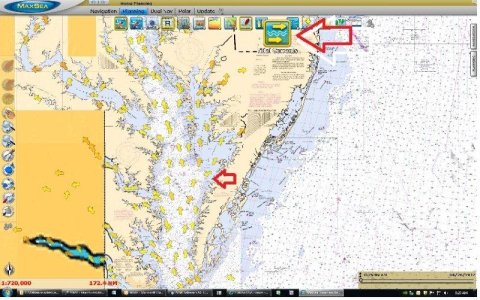
You can turn on the Tidal Currents icon to view graphically the available information.TZtidal Currents.jpg

when I download an Ocean Current forecast from Chopper, how is this combined with the pre-programmed current data ?

It is not. Only the Oceanic Current are taken into account for Routing. Tidal currents are only available for intra coastal water. The Routing is usually performed in open water (where there is no tidal current available).

when a route is active how does the 'Assign Tidal Current' right mouse click function work ?

You can't do it with an active route. You can only assign manually a Tidal Current on a planning Route.
 
Johnny, Thanks for being extremely helpful.
Concerning the the first point:
When I calculate a route, MaxSea appears to use pre-programmed current data to calculate the route.In the 'Route List' Current speed and direction is shown. I have no active grib file containing Ocean Currents. Where does this data come from. I am currently off the South East Coats of Mexico.
To the last point: I still can't use 'Assign Tidal Current' in planning route mode, - I get a current vector with the mouse right click but it does not do anything ??
 
It looks like there are lots of unknown functions in MaxSea - even MaxSea don't know about ? There is nothing in the manual either !
 
I am not sure whom you spoke with at MaxSea but they provided me an answer.

Where does this data come from?
It comes from the last ocean current GRIB file that was opened. Ocean currents are “persistent” in the software until you exit the software (even if you download a new GRIB file without current or hide the data). Here is an example (you can try):
- You download a GRIB file with Ocean Current and make a route on the corresponding area. The route detail show currents data (normal!)
- You download another GRIB file without current data. The Current data disappear from the charts but is still available in the background and is used if a new route is created. If you restart the software, the current data is not there anymore (until you download a new GRIB file with Current Data)
Note that from a practical point of view, the Oceanic Current don’t really impact a Planning Route (they impact routing little at most).

I still can't use 'Assign Tidal Current' in planning route mode
This is only for Tidal Currents (like the title of the function suggests). Maybe you are trying to attach a route leg to a Ocean Current arrow, and not Tidal Current arrow? I just tried (again) attaching to a tidal current (yellow arrow) and it is working fine. Please note, we have tidal currents only for North America, so if you are in Mexico, you cannot attach any tidal current (because they don’t exist).
 
Johnny, once again you have done an excellent job answering my querries. Being a full time cruiser in relatively remote parts of the world the only way to contact MaxSea is via email. Unfortunately, their email queries appear to be answered from France and they do not understand me too well to say the least ! I have been asking these questions for a long time and never got sensible answers. You are my saviour !!
Incidentally, where I have made recent long passages in the Caribbean Ocean, the ocean current effects of the Gulf Stream etc influences planning significantly. A 1 knot current against you on a sailing boat makes a big difference over 24 hours. MSTZ should make it clear where it gets the current data from, not just some arbitrary GRIB file which may have been used several week ago. Any way I now know. Thanks again.
Richard
 
Status
Not open for further replies.
Back
Top